Bad-breisig Germany
Europe´s bigest motorhome-portal
from motorhome drivers for motorhome driver
start
Bad-breisig, Information and images
- Route 1: Rhein-Lahn <9> Bad Hönningen / Rheinbrohl to Bad Ems <9> Province: Germania superior <9> <9> <9> Type name; <9> Location, <9> Coordinates <9> Description <9> <9> Small fort Rheinbrohl; <9> 56598 Rheinbrohl, <9> N50. 503523, E7. 31931 <9> completely destroyed (gravel mining <9> <9> reconstructed watchtower, Wp 1/1; <9> 56598 Rheinbrohl, <9> N50. 503611, E7. 318055 <9> <9> watchtower Wp 1/2; <9> 56598 Rheinbrohl, <9> N50.50915, E7. 3232 <9> No recognizable traces <9> <9> Watchtower Wp 1/3; <9> 56598 Arienheller, <9> N50. 51059, E7. 33161 <9> No recognizable traces <9> <9> Watchtower Wp 1/4, <9> 56598 Arienheller, <9> N50. 51305, E7. 33728 <9> No recognizable traces <9> <9>Stone tower Wp 1/5 Am Berdelder; <9> 56598 Arienheller, <9> N50. 51324, E7. 3427 <9> Slightly recognizable traces <9> <9> Watchtower Wp 1/6; <9> 56598 Rheinbrohl, <9> N50. 51351, E7. 34921 <9> A watchtower is assumed here due to the distances involved. <9> <9> Wooden tower Wp 1/7 on the Steinbrink; <9> 56598 Rheinbrohl, <9> N50. 51382, E7. 35619 <9> There is only a pile of rubble of the 4.20 x 4.30 m tower. <9> <9> Wooden tower Wp 1/8 on Hottels Buchen; <9> 56598 Rheinbrohl, <9> N50. 513175, E7. 36557 <9> There are still mounds of rubble from 2 towers: the western one measures 4.20x4.25 m, the eastern 4.65x4.65 m. <9> <9> Wooden tower Wp 1/9 Am Beulenberg; <9> 56598 Rheinbrohl, <9> N50. 51151, E7. 37164 <9> Originally a wooden tower stood here.From the later stone tower, dimensions 4.1x4.1m, only slight traces of the ground can be seen. <9> <9> Stone tower Wp 1/10 On the Marsfeld; <9> 56598 Rheinbrohl, <9> N50. 51031, E7. 37572 <9> There is only one pile of rubble of the 4.40 x 4.40 m tower. Traces of fire suggest that a wooden tower previously stood here. <9> <9> Stone tower Wp 1/11 on the Freßhelder; <9> 56598 Rheinbrohl, <9> N50. 50397, E7. 37664 <9> In the visible hill are the remains of the foundations of the 4.3x4.3m stone tower. <9> <9> Stone tower Wp 1/12 at the Weierhof; <9> 56598 Rheinbrohl, <9> N50. 49987, E7. 37991 <9> There is only one pile of rubble of the 4.80 x 4.80 m tower. <9> <9> Wooden tower Wp 1/13 Am Rennweg; <9> 56598 Hammerstein, <9> N50. 49471, E7.38631 <9> Remnants of the 5.3x5.3m tower can still be seen. <9> <9> Watchtower Wp 1 / 13a; <9> 56598 Hammerstein, <9> N50. 49448, E7. 39008 <9> A presumed unproven location. <9> <9> Stone tower Wp 1/14 Am Forsthofweg; <9> 56598 Hammerstein, <9> N50. 49440, E7. 39284 <9> You can see slight deformations of the railing due to a pile of rubble in the 4.30 x 4.50 m tower. <9> <9> Small fort on the Forsthofweg; <9> 56599 Leutesdorf, <9> N50. 49444, E7. 39388 <9> No recognizable traces <9> <9> Watchtower Wp 1/15; <9> 56599 Leutesdorf, <9> N50. 49446, E7. 39759 <9> A presumed unproven location. <9> <9> Stone tower Wp 1/16 Am Heideweg; <9> 56599 Leutesdorf, <9> N50. 49133, E7. 39873 <9>On the visible tower hill stood a 4.15x4.15m stone tower. <9> <9> Wooden tower Wp 1/17 Am Rothestalweg; <9> 56564 Neuwied Wollendorf, <9> N50. 48711, E7. 39953 <9> There is only a barely visible mound of rubble of the 4.20 x 4.20 m tower. Excavations have also shown the pillars of a wooden tower. <9> <9> Wooden tower Wp 1/18 On the roots; <9> 56564 Neuwied Wollendorf, <9> N50. 48222, E7. 40433 <9> There are still flat mounds of rubble of 2 towers: the western one measures 4.20 x 4.20 m, the eastern one 4.50 x 4.50 m. <9> <9> Stone tower Wp 1/19 At the foot of the root; <9> 56564 Neuwied Hüllenberg, <9> N50. 47651, N7. 40610 <9> Barely visible rubble hill <9> <9> Stone tower Wp 1/20 Am Tampurhäuschen; <9> 56564 Neuwied Gönnersdorf, <9> N50. 47278, E7. 4074 <9> There is only a pile of rubble of the 4.10 x 4.10 m tower. <9> <9> Wooden tower Wp 1/21 Am Gebranntehof; <9> 56564 Neuwied Wollendorf, <9> N50. 469789, E7. 41305 <9> The tracks were destroyed during construction work. <9> <9> Stone tower Wp 1/22 Auf der Schurbusch; <9> 56564 Neuwied Wollendorf, <9> N50. 46683, E7. 41971 <9> There is only one pile of rubble of the 4.00 x 4.00 m tower. <9> <9> Stone tower Wp 1/23 In Eckerts Fichten; <9> 56564 Neuwied Wollendorf, <9> N50. 46607, E7. 42554 <9> Slightly recognizable soil deformation of a 4.00x4.00m tower <9> <9> Watchtower Wp 1/24; <9> 56564 Neuwied Wollendorf, <9> N50. 46436, E7. 43063 <9> A presumed unproven location. <9> <9>Wooden tower / stone tower Wp 1/25 Im Gewann Kalbeizer; <9> 56564 Neuwied Rodenbach, <9> N50. 4634, E7. 43525 <9> Slightly recognizable soil deformations of the stone tower. In the same place there was a wooden tower. <9> <9> Wooden tower / stone tower Wp 1/26 Im Gewann Auf dem Busch; <9> 56564 Neuwied Rodenbach, <9> N50. 461775, E7. 44184 <9> Here was a hexagonal tower with a diameter of 5.5 m. Before that there was a wooden tower. <9> <9> Antunnacum / Andernach cohort fort; <9> N50. 44014, E7. 3975 <9> Nothing more can be seen of the fort. Parts of a late antique bath have been preserved. <9> <9> Cohort fort Heddesdorf; <9> N50. 43653, E7. 46931 <9> Almost completely built over, a fragment of the wall has been preserved. <9> <9> Watchtower Wp 1/27; <9>56564 Neuwied Rodenbach, <9> N50. 46333, E7. 44738 <9> A suspected unproven location. <9> <9> Watchtower Wp 1/28; <9> 56564 Neuwied Niederbieber-Segendorf, <9> N50. 46592, E7. 45261 <9> A presumed unproven location. <9> <9> Stone tower Wp 1/29; <9> 56564 Neuwied Niederbieber-Segendorf, <9> N50. 46584, E7. 45796 <9> No recognizable traces <9> Finds of rubble and ceramic shards during excavations by the RLK resulted in a tower location. <9> <9> Watchtower Wp 1/30; <9> 56564 Neuwied Niederbieber-Segendorf, <9> N50. 46762, E7. 46458 <9> A suspected unproven location. <9> <9> Watchtower Wp 1/31; <9> 56564 Neuwied Niederbieber-Segendorf, <9> N50. 47076, E7. 47291 <9>A suspected unproven location. <9> <9> Watchtower Wp 1/32; <9> 56564 Neuwied Altwied, <9> N50. 47474, E7. 47621 <9> A presumed unproven location. <9> <9> Niederbieber fort; <9> 56564 Neuwied Niederbieber-Segendorf, <9> N50. 46702, E7. 47194 <9> <9> Stone tower Wp 1/33 At the Kreuzkirche; <9> 56564 Neuwied Altwied, <9> N50. 47877, N7. 48022 <9> There are no more traces of the two square stone towers, 4.50m and 4.85m. <9> <9> Watchtower Wp 1/34; <9> 56564 Neuwied Oberbieber, <9> N5047876, E7. 48634 <9> A suspected unproven location. <9> <9> Watchtower Wp 1 / 35a; <9> 56564 Neuwied Oberbieber, <9> N50. 47734, E7. 49488 <9> A presumed unproven location.<9> <9> Watchtower Wp 1/35; <9> 56564 Neuwied Oberbieber, <9> N50. 47679, E7. 4987 <9> A presumed unproven location. <9> <9> stone tower Wp 1/36; <9> 56564 Neuwied Oberbieber, <9> N50. 47663, E7. 50217 <9> Finds by the RLK suggest a location. <9> <9> Reconstructed wooden tower ´Wp 1/37 Auf dem Wingertsberg; <9> 56564 Neuwied Oberbieber, <9> N50. 477767, E7. 50960 <9> <9> Watchtower Wp 1 / 37a; <9> 56564 Neuwied Oberbieber, <9> N50. 47831, E7. 51557 <9> No recognizable traces <9> <9> Wooden tower Wp 1/38; <9> 56564 Neuwied Gladbach, <9> N50. 47835, E7. 51779 <9 > Slightly recognizable traces <9> <9> Steinturm Wp 1/39; <9> 56564 Neuwied Gladbach, <9> N50. 47932, E7. 52319 <9>Slightly recognizable traces <9> <9> stone tower Wp 1/40; <9> 56564 Neuwied Gladbach, <9> N50. 48121, E7. 53144 <9> Slightly recognizable traces <9> <9> Wooden tower Wp 1/41; <9> 56564 Neuwied Heimbach-Weis, <9> N50. 48196, E7. 53817 <9> No recognizable traces <9> <9> Wooden tower Wp 1/42; <9> 56564 Neuwied Heimbach-Weis, <9> N50. 47813, E7. 54328 <9> Slightly recognizable traces <9> <9> Stone tower Wp 1/43; <9> 56564 Neuwied Heimbach-Weis, <9> N50. 47454, E7. 55015 <9> Slightly recognizable traces <9> <9> Wooden tower Wp 1/44; <9> 56564 Neuwied Heimbach-Weis, <9> N50. 47357, E7. 56001 <9> Slightly recognizable traces <9> <9> Stone tower Wp 1/45; <9> 56564 Neuwied Heimbach-Weis, <9> N50. 47064, E7. 56296 <9> No recognizable traces <9> <9> wooden tower Wp 1/46; <9> 56564 Neuwied Heimbach-Weis, <9> N50. 46831, E7. 56501 <9> No recognizable traces <9> <9> Wooden tower Wp 1/47; <9> 56564 Neuwied Heimbach-Weis, <9> N50. 46353, E7. 56898 <9> Slightly recognizable traces <9> <9> Wooden tower Wp 1/48; <9> 56564 Neuwied Heimbach-Weis, <9> N50. 45685, E7. 57221 <9> Slightly recognizable traces <9> <9> Wp 1/49; <9> 56564 Neuwied Heimbach-Weis, <9> N50. 4505, E7. 57196 <9> No recognizable traces <9> <9> Stone tower Wp 1/50; <9> 56170 Bendorf Sayn, <9> N50. 44839, E7. 57683 <9> No recognizable traces <9> <9> Watchtower Wp1 / 51; <9> 56170 Bendorf Sayn, <9> N50. 44602, E7. 58082 <9> No recognizable traces <9> <9> Wooden tower Wp 1/52; <9>56170 Bendorf Sayn, <9> N50. 44312, E7. 58571 <9> Slightly recognizable traces <9> <9> Watchtower Wp 1/53 <9> 56170 Bendorf Sayn, <9> N50. 4425, E7. 59241 <9> No recognizable traces <9> <9> Wooden tower Wp 1/54; <9> 56170 Bendorf Sayn, <9> N50. 44192, E7. 59811 <9> Slight recognizable traces <9> <9> Wooden tower Wp 1/55; <9> 56170 Bendorf Sayn, <9> N50. 44230, E7. 60518 <9> Slightly recognizable traces <9> <9> Wooden tower Wp 1/56; <9> 56170 Bendorf Sayn, <9> N50. 44226, E7. 61328 <9> Slightly recognizable traces <9> <9> Wooden tower Wp 1/57; <9> 56170 Bendorf, <9> N50. 43978, E7. 61691 <9> No recognizable traces <9> <9> Wooden tower Wp 1/58; <9> 56170 Bendorf, <9> N50. 43772, 7. 62292 <9> Slightly recognizable traces <9><9> Stone tower Wp 1/59; <9> 56170 Bendorf, <9> N50. 43806, E7. 63323 <9> Slightly recognizable traces <9> <9> Wooden tower Wp 1/60; <9> 56170 Bendorf, <9> N50. 43736, E7. 64021 <9> Slightly recognizable traces <9> <9> Small fort Ferbach; <9> N50. 43039, E7. 65227 <9> invisible ground monument <9> <9> small fort Anhausen; <9> N50. 48134, E7. 53841 <9> perceptible soil deformations <9> <9> watchtower Wp 1/61; <9> 56191 Weitersburg, <9> N50. 43525, E7. 64419 <9> No recognizable traces <9> <9> Watchtower Wp 1/62; <9> 56191 Weitersburg, <9> N50. 43285, E7. 64848 <9> No recognizable traces <9> <9> Small fort Ferbach, <9> 56203 Höhr-Grenzhausen, <9> N50. 43038, E7. 65227 <9>Invisible ground monument <9> <9> watchtower Wp 1/63; <9> 56203 Höhr-Grenzhausen, <9> N50. 43069, E7. 65359 <9> No recognizable traces <9> <9> Stone tower Wp 1/64; <9> 56203 Höhr-Grenzhausen, <9> N50. 42791, E7. 65855 <9> No recognizable traces <9> <9> Wooden tower Wp 1/64; <9> 56203 Höhr-Grenzhausen, <9> N50. 42701, E7. 660408 <9> No recognizable traces <9> <9> Wooden tower Wp 1/65; <9> 56203 Höhr-Grenzhausen, <9> N0. 42331, E7. 66711 <9> Slightly recognizable traces <9> <9> Stone tower Wp 1/66; <9> 56203 Höhr-Grenzhausen, <9> N50. 42093, E7. 67427 <9> No recognizable traces <9> <9> Stone tower Wp 1/67; <9> 56204 Hillscheid, <9> N50. 41799, E7. 68154 <9> Slightly recognizable traces <9> <9>Reconstructed stone tower Wp 1/68; <9> N50. 414791, E7. 68970 <9> <9> stone tower Wp 1/69; <9> 56204 Hillscheid, <9> N50. 41261, E7. 71358 <9> No recognizable traces <9> <9> Hillscheidt small fort; <9> 56204 Hillscheid, <9> N50. 41119, E7. 71068 <9> Slightly recognizable traces <9> <9> Watchtower Wp 1/70; <9> 56204 Hillscheid, <9> N50. 41214, E7. 70495 <9> No recognizable traces <9> <9> Wooden tower Wp 1/71; <9> 56204 Hillscheid, <9> N50. 41128, E7. 71009 <9> Slightly recognizable traces <9> <9> Stone tower Wp 1/72; <9> 56204 Hillscheid, <9> N50. 40744, E7. 71261 <9> Slightly recognizable traces <9> <9> Stone tower Wp 1/73; <9> 56204 Hillscheid, <9> N50. 40306, E7. 71686 <9> Slightly recognizable traces <9> <9>Watchtower Wp 1/74; <9> 56337 Eitelborn, <9> N50. 3995, E7. 71872 <9> No recognizable traces <9> <9> Stone tower Wp 1/75; <9> 56337 Eitelborn, <9> N50. 39731, E7. 72348 <9> Slightly recognizable traces <9> <9> Watchtower Wp 1/76; <9> 56337 Kadenbach, <9> N50. 39515, E7. 72864 <9> No recognizable traces <9> <9> Watchtower Wp 1/77; <9> 56337 Kadenbach, <9> N50. 39666, E7. 73456 <9> No recognizable traces <9> <9> Wooden tower Wp 1/78; <9> 56337 Kadenbach, <9> N50. 39644, E7. 74067 <9> Slightly recognizable traces <9> <9> Stone tower Wp 1/79; <9> 56337 Kadenbach, <9> N50. 39102, E7. 74187 <9> No recognizable traces <9> <9> Stone tower Wp 1/80; <9> 56337 Kadenbach, <9> N50. 38569, E7. 7394 <9>No recognizable traces <9> <9> stone tower Wp 1/81; <9> 56337 Arzbach, <9> N50. 38091, E7. 74024 <9> No recognizable traces <9> <9> Niederberg cohort fort; <9> 56077 Koblenz-Niederberg, <9> N50. 36886, E7. 62734 <9> ground monument not visible above ground <9> <9> Numerus fort Arzbach; <9> 56337 Arzbach, <9> N50. 37533, E7. 74565 <9> largely overbuilt <9> <9> watchtower Wp 1/82; <9> 56337 Arzbach, <9> N50. 3766, E7. 74379 <9> No recognizable traces <9> <9> Stone tower Wp 1/83; <9> 56337 Arzbach, <9> N50. 37421, E7. 74995 <9> No recognizable traces <9> <9> Reconstructed wooden tower Wp 1/84; <9> 56337 Arzbach, <9> N50. 36986, E7. 7565 <9> <9> stone tower Wp 1/88; <9> 56132 Kemmenau, <9> N50. 35832, E7. 76061 <9> Slightly recognizable traces <9> <9> Stone tower Wp 1/89; <9> 56132 Kemmenau, <9> N50. 35165, E7. 75115 <9> No recognizable traces <9> <9> Stone tower Wp 1/90; <9> 56132 Kemmenau, <9> N50. 34704, E7. 74545 <9> No recognizable traces <9> <9> Stone tower Wp 1/92; <9> 56130 Bad Ems, <9> N50. 33771, E7. 73704 <9> Slightly recognizable traces <9> <9> Numeruskastell Ems; <9> 56130 Bad Ems, <9> N50. 33592, 7. 713 <9> completely built over <9> <9> watchtower Wp 1/93; <9> 56130 Bad Ems, <9> N50. 33424, E7. 73271 <9> No recognizable traces <9> <9>9> No recognizable traces <9> <9> Stone tower Wp 1/90; <9> 56132 Kemmenau, <9> N50. 34704, E7. 74545 <9> No recognizable traces <9> <9> Stone tower Wp 1/92; <9> 56130 Bad Ems, <9> N50. 33771, E7. 73704 <9> Slightly recognizable traces <9> <9> Numerus fort Ems; <9> 56130 Bad Ems, <9> N50. 33592, 7. 713 <9> completely built over <9> <9> watchtower Wp 1/93; <9> 56130 Bad Ems, <9> N50. 33424, E7. 73271 <9> No recognizable traces <9> <9>9> No recognizable traces <9> <9> Stone tower Wp 1/90; <9> 56132 Kemmenau, <9> N50. 34704, E7. 74545 <9> No recognizable traces <9> <9> Stone tower Wp 1/92; <9> 56130 Bad Ems, <9> N50. 33771, E7. 73704 <9> Slightly recognizable traces <9> <9> Numerus fort Ems; <9> 56130 Bad Ems, <9> N50. 33592, 7. 713 <9> completely built over <9> <9> watchtower Wp 1/93; <9> 56130 Bad Ems, <9> N50. 33424, E7. 73271 <9> No recognizable traces <9> <9>Numerus fort Ems; <9> 56130 Bad Ems, <9> N50. 33592, 7. 713 <9> completely built over <9> <9> watchtower Wp 1/93; <9> 56130 Bad Ems, <9> N50. 33424, E7. 73271 <9> No recognizable traces <9> <9>Numerus fort Ems; <9> 56130 Bad Ems, <9> N50. 33592, 7. 713 <9> completely built over <9> <9> watchtower Wp 1/93; <9> 56130 Bad Ems, <9> N50. 33424, E7. 73271 <9> No recognizable traces <9> <9>
1749882
 | Town
Bad Breisig
Bad Breisig ist eine Kurstadt am Rhein, die sich in Rheinland-Pfalz befindet. Die Stadt ist bekannt für ihre Thermalquellen und hat sich zu einem beliebten Reiseziel für Touristen entwickelt.
E. . . FURTHER . . . [001.65]
| TownBad Hönningen
Bad Hönningen ist eine kleine Stadt in Rheinland-Pfalz, die direkt am Rhein gelegen ist und von Weinbergen und Wäldern umgeben ist. Die Stadt hat eine lange Geschichte und geht auf eine römische Siedl. . . FURTHER . . . [002.05]


Video films of the place and surroundings


-
Motorhome place

 53498 Bad Breisig Rhineland-Palatinate Germany
without charge 0,00 Euro


")


open Januar until Januar


Motorhome place campsite Rheineck
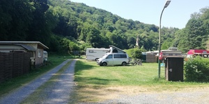
 53498 Bad Breisig, Mühlenstraße Rhineland-Palatinate Germany
Pay for use site 23 Euro


")
")


open 1.Januar until 31.Dezember
Motorhome place Römer Therme
 53498 Bad Breisig Rhineland-Palatinate Germany
without charge


open Januar until Dezember
 Selected parking spaces
 | Parking suitable for campers over 5 m
deutschland 56598 Rheinbrohl Arienheller
Hiking car park - this is where the Limes circular trail starts (if you want with a small extension to the Malbergsee)
Hiking car park - this is where the Limes circular trail starts (if you want with a small extension to the Malbergsee)
| Parking suitable for campers over 5 mParkplatz Rheinallee
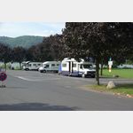 deutschland 53557 Bad Hönningen Rheinallee
Daytime slot only from 8 a.m. to 10 p.m
 | Parking lot cemetery
Parkplatz am
deutschland 53498 Bad Breisig Breslauer Straße
 | unclear usage
Koblenzer Straße 35, 53498 Bad Breisig, Deutschland
 |
| Parkenprivat
deutschland 53498 Bad Breisig K 47
 |
| Parkplatz Hohe Buche
deutschland 56626 Eich
Selected sights
 | lock
Schloss Burg Namedy Andernach
deutschland 56626 Andernach Schlossstraße
Namedy Castle is a historic castle complex from the 14th century, located near Andernach on the Rhine. The castle has been rebuilt and expanded several times over the centuries and is now a popular ve. . . FURTHER . . .
Namedy Castle is a historic castle complex from the 14th century, located near Andernach on the Rhine. The castle has been rebuilt and expanded several times over the centuries and is now a popular ve. . . FURTHER . . .
 | Skulpturenwege
Skulpturenufer in Remagen
Deutschland 53424 Remagen
The path consists of 15 works of art on the left bank of the Rhine.
Michael Volkmer: ´Lapsus´ sculpture, Kripp 50. 56325, 7. 27438
Johannes Brus: ´Towing barge with bronze horses´ sculpture (Rh. . . FURTHER . . .
The path consists of 15 works of art on the left bank of the Rhine.
Michael Volkmer: ´Lapsus´ sculpture, Kripp 50. 56325, 7. 27438
Johannes Brus: ´Towing barge with bronze horses´ sculpture (Rh. . . FURTHER . . .
 | Castle
Burgruine Hammerstein
deutschland 56599 Hammerstein B 42
The Hammerstein castle ruins are a historic castle complex located on a rock high above the Rhine. It lies between the towns of Bad Hönningen and Linz on the Rhine and is a popular destination for tou. . . FURTHER . . .
The Hammerstein castle ruins are a historic castle complex located on a rock high above the Rhine. It lies between the towns of Bad Hönningen and Linz on the Rhine and is a popular destination for tou. . . FURTHER . . .
 | Hiking
Rheinsteig Bad Hönningen - Leutesdorf
deutschland 53557 Bad Hönningen
16 km with medium difficulty
Rheinsteig
The total length is 320 km, few routes are more difficult.
This proposal contains 21 stages.
Bonn, 3018930; Koenigswinter, 3018926; Bad Honnef, 30. . . FURTHER . . .
16 km with medium difficulty
Rheinsteig
The total length is 320 km, few routes are more difficult.
This proposal contains 21 stages.
Bonn, 3018930; Koenigswinter, 3018926; Bad Honnef, 30. . . FURTHER . . .
| HikingRheinstig Linz - Bad Hönningen
deutschland 53545 Linz am Rhein
13 km with medium difficulty
Rheinsteig
The total length is 320 km, few routes are more difficult.
This proposal contains 21 stages.
Bonn, 3018930; Koenigswinter, 3018926; Bad Honnef, 30. . . FURTHER . . .
13 km with medium difficulty
Rheinsteig
The total length is 320 km, few routes are more difficult.
This proposal contains 21 stages.
Bonn, 3018930; Koenigswinter, 3018926; Bad Honnef, 30. . . FURTHER . . .
Selected service points
 | AmazonHub
Amazon Hub Locker - keaka
deutschland 53489 Sinzig Rheinallee 12
 | car wash
Total Tankstelle
deutschland 53545 Linz am Rhein
 | public restroom
WC
deutschland 53498 Bad Breisig
Selected gastronomy
 | restaurant
Historisches Weinhaus Templer Hof
deutschland 53498 Bad Breisig Koblenzer Straße 45
very good food, cozy ambience, international cuisine, closed on Wednesdays
very good food, cozy ambience, international cuisine, closed on Wednesdays
 | Luxury Hotel
Schloss Burgbrohl
56659 Buchholz Auf der Burg
 | Bar
| BarJimmy s Coctail &«,» Sisha Bar
deutschland 53545 Linz am Rhein
 | Biergarten
Biergarten
deutschland 53489 Landkreis Ahrweiler
motorhome places Bad-breisig in these books
General Pois
 | Other
sonstiges
Caravan Center Breisig CCB
Full service for mobile homes and caravans,
53498 Bad Breisig, Koblenzer Str. 62
Truma dealership
Tel. 02633/4756675
fax. 02633/4756676
info
ccb-badbre. . . FURTHER . . .
Full service for mobile homes and caravans,
53498 Bad Breisig, Koblenzer Str. 62
Truma dealership
Tel. 02633/4756675
fax. 02633/4756676
info
ccb-badbre. . . FURTHER . . .
 | station
Bahnhof
Starting point of the Brohltalbahn narrow-gauge railway via Burgbrohl, Niederzissen, Oberzissen to Engeln. Sometimes steam train rides. Contemplative journey through the Brohltal. Is used as a museum . . . FURTHER . . .
 | Spa
| SpaKristall Rheinpark-Therme
Deutschland 53557 Bad Hönningen Allée St. Pierre les Nemours 1
* Thermal healing water containing sodium-magnesium-hydrocarbonate-chloride, from a depth of 370 m
* various indoor and outdoor pools 31 - 35 °C
* Thermal healing water containing sodium-magnesium-hydrocarbonate-chloride, from a depth of 370 m
* various indoor and outdoor pools 31 - 35 °C
 | Tourist Info
TouristInfo
Deutschland 53557 Bad Hönningen Neustraße 1a
Tourist-Information Bad Hönningen
Open all year round:
Monday - Friday 8.30 am - 5.00 pm
Saturday 9.30 am - 12.00 pm (except Nov. -Feb.)
Tourist-Information Bad Hönningen
Open all year round:
Monday - Friday 8.30 am - 5.00 pm
Saturday 9.30 am - 12.00 pm (except Nov. -Feb.)
| Tourist InfoTouristInfo
Deutschland 53498 Bad Breisig Koblenzer Straße 35-41
Tourist-Information Bad Breisig
Opening times:
Monday to Friday
from 9.00 a.m. to 5.30 p.m. (continuous)
Tourist-Information Bad Breisig
Opening times:
Monday to Friday
from 9.00 a.m. to 5.30 p.m. (continuous)