Bensersiel Germany
Europe´s bigest motorhome-portal
from motorhome drivers for motorhome driver
start
Bensersiel, Information and images
- 1345911_WikTx
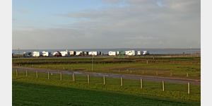
1345911 - UNESCO World Heritage Wadden Sea <9> <9> There, where else the seabed is located - this is possible here on the North Sea, where ebb and flow alternate.. It is a unique experience to stand in the middle of the mudflats - all around only silence and infinite space.. Sometimes the sand under your feet is very firm, then you dive a bit deeper into the soft mud and elsewhere you can observe how water collects spirally in the turf.. Experience this incredibly fascinating and peaceful habitat with all your senses and become one with nature.. Keep your eyes peeled, because here are not only crabs, shells, lugworms and seals at home, but also around 3,000 different animal and plant species.. Some of them exist worldwide only in this place - one of the last original natural landscapes of Central Europe.. <9> <9> <994/962013> <994/962010> <994/962008> <994/20885> <9> <994/1148228>, <994/1148227>, <994/1148226> <994/1148229> <9> <994/1139732>, <994/1139734> <994/1139736>, <994/1255760>
1346379 - <123> World Heritage Wadden Sea <122> <9> The Wadden Sea is the largest contiguous area of ââsilt and sand in the world, with natural dynamic processes that take place in a largely undisturbed natural state.. <9> Together with the barrier islands and salt marshes, the Wadden Sea represents one of the most important international wetlands and forms the basis for exceptionally high biological production and biodiversity as well as a high degree of ecological specialization and adaptability.. It is a prime example of the ongoing Holocene evolution of a sand coast under conditions of rising sea levels, and is unique in that it is the largest wadding and barrier island deposition system in the world.. Its geological and geomorphological features are intimately intertwined with biophysical processes and are invaluable to the ongoing dynamic adaptation of coastal habitats to global change.. <9> Because of the high primary and secondary production, the Wadden Sea supports a variety of bird, fish and fish farming.. and crustaceans as well as seals well beyond its borders.. The rich and diverse habitats are of exceptional international importance as an essential habitat for migratory waterbird species using the East Atlantic migration route between South Africa, northeastern Canada and northern Siberia.. It is one of the few shallow marine areas in the northern hemisphere with high fish production and is an indispensable area for species migrating between fresh and salt water, for spawning and foraging and for juvenile juveniles. The mosaic of natural phenomena with complex geomorphological features and Biologically diverse and rich habitats, the unparalleled vastness of space, and the millions of migratory birds that pervade spring and autumn make up one of the most extraordinary, beautiful and awe-inspiring landscapes and seascapes in the world.. <9> In Lower Saxony, the area covered by the World Natural Heritage ´Wadden Sea´ covers approximately 280,000 hectares. Thus, the share of Lower Saxony in the World Natural Heritage Area nominated jointly with Schleswig-Holstein and the Netherlands amounts to approximately 30%.. The national park ´Niedersächsisches Wattenmeer´ extends in the west from the Dutch border in the mouth of the Ems (Dollart, Borkum) to the Elbe (Cuxhaven) on the border to Schleswig-Holstein.. The shipping routes in Ems, Jade, Weser and Elbe are excluded.. <9> <9> Three large landscape types characterize the World Heritage Site in Lower Saxony: <9> * The <151> East Frisian Islands <152> with their high dunes and natural salt marshes in the west are an integral part of the geomorphologically important Wadden Sea and Barrier Island sedimentation system ,. To the east, from about the jade, the higher tidal range no longer permits the formation of barrier islands, where they are replaced by sandbanks and outer sands.. <9> * The <151> mudflats <152> between the islands and the mainland with the extensive sandy, mixed and muddy mud, which reach an extent of up to 20 km in the Elbe-Weser area and which are characterized by widely ramified trough and tidal systems. and dehydrated.. Immediately upstream of the dikes on the mainland coast are again salt marshes, which were usually created here by humans.. <9> * With the Jadebusen, Leybucht and the share of the Dollart <152>, the Wadden Sea of ââLower Saxony has large Wadden Sea bays, which were created by medieval sea burglaries.. In the swell protected parts of these bays powerful mudflats with their special living conditions have been created.. In many places, the characteristic sequence of sandy, mixed and muddy mud, silting belt, wide salt marshes and dykes is pronounced and the physical fever can be experienced on a guided National Park mudflat hike.. <9> In the Lower Saxon Wadden Sea with its mudflats, torrents and tidal troughs, the dune islands and salt marshes, the abundance of partial habitats, whether it was pierworm-shaped sand wadding, mosaics of salt marsh types or various dune stages, has been preserved.. They can be explored through a system of routes and routes or on guided hikes.. The World Heritage Site can be experienced in the National Park.. <9> <9> Here is a lot more information about the <1001> World Heritage Site}
1368996 - <123> Wadden Sea World Heritage <122> <9> The Wadden Sea is the largest contiguous area of ââsilt and sand wadding in the world with natural dynamic processes that take place in a largely undisturbed natural state <9> Satellite image of the Lower Wadden Sea <9> <9> With the barrier islands and salt marshes, the Wadden Sea represents one of the most important international wetlands and forms the basis for an extraordinarily high biological production and biodiversity as well as a high degree of ecological specialization and adaptability.. It is a prime example of the ongoing Holocene evolution of a sand coast under conditions of rising sea levels, and is unique in that it is the largest wadding and barrier island deposition system in the world.. Its geological and geomorphological features are intimately intertwined with biophysical processes and are invaluable to the ongoing dynamic adaptation of coastal habitats to global change.. <9> <9> Because of the high primary and secondary production, the Wadden Sea supports a variety of bird, fish and fish farming.. and crustaceans as well as seals well beyond its borders.. The rich and diverse habitats are of exceptional international importance as an essential habitat for migratory waterbird species using the East Atlantic migration route between South Africa, northeastern Canada and northern Siberia.. It is one of the few shallow marine areas in the northern hemisphere with high fish production and is an indispensable area for species migrating between fresh and salt water, for spawning and foraging and for juvenile juveniles. The mosaic of natural phenomena with complex geomorphological features and Biologically diverse and rich habitats, the unparalleled vastness of space, and the millions of migratory birds that pervade spring and autumn make up one of the most extraordinary, beautiful and awe-inspiring landscapes and seascapes in the world.. <9> <9> In Lower Saxony, the area of ââthe World Natural Heritage ´Wadden Sea´ covers approximately 280,000 hectares. Thus, the share of Lower Saxony in the World Natural Heritage Area nominated jointly with Schleswig-Holstein and the Netherlands amounts to approximately 30%.. The national park ´Niedersächsisches Wattenmeer´ extends in the west from the Dutch border in the mouth of the Ems (Dollart, Borkum) to the Elbe (Cuxhaven) on the border to Schleswig-Holstein.. The shipping routes in Ems, Jade, Weser and Elbe are excluded.. <9> <9> Three large landscape types characterize the World Heritage Site in Lower Saxony: <9> <9> * The <151> East Frisian Islands <152> with their high dunes and natural salt marshes in the west are an integral part of the geomorphologically significant Wadden Sea and Barrier seabed deposit system.. To the east, from about the jade, the higher tidal range no longer permits the formation of barrier islands, where they are replaced by sandbanks and outer sands.. <9> * The <151> mudflats <152> between the islands and the mainland with the extensive sandy, mixed and muddy mud, which reach an extent of up to 20 km in the Elbe-Weser area and which are characterized by widely ramified trough and tidal systems. and dehydrated.. Immediately upstream of the dikes on the mainland coast are again salt marshes, which were usually created here by humans.. <9> * With the Jadebusen, Leybucht and the share of the Dollart <152>, the Lower Saxony Wadden Sea has large Wadden Sea bays, which were created by medieval sea burglaries.. In the swell protected parts of these bays powerful mudflats with their special living conditions have been created.. In many places, the characteristic sequence of sandy, mixed and muddy mud, silting belt, wide salt marshes and dykes is pronounced and the physical fever can be experienced on a guided National Park mudflat hike.. <9> <9> In the Lower Saxon Wadden Sea with its mudflats, torrents and tidal channels, the dune islands and salt marshes, the abundance of partial habitats, be it pierworm-shaped sand wadding, mosaics of salt marsh types or various dune stages, has been preserved.. They can be explored through a system of routes and routes or on guided hikes.. The World Heritage Site can be experienced in the National Park.. <9> <9> There is much more information about the <1001> Wadden Sea <9>
1369006


Video films of the place and surroundings


-
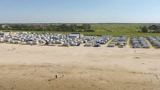
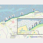
Motorhome place Strand- und Familiencampsiteplatz Bensersiel
 26427 Bensersiel Lower Saxony,HH,HB Germany
Pay for use site 35.4 until 41.4 Euro


")
")


open 23.März until 20.Oktober


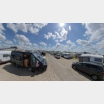
Motorhome place campsite Bensersiel
 26427 Bensersiel Germany
Pay for use site 23 until 17 Euro


open 1.November until 15.März
 Selected parking spaces
 | Other
Scheuerpfahl Skulpturen
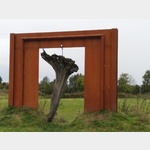 Scheuerpfahl sculptures on the Ostfriesland hiking trail An art project that connects East Frisia - and where people and animals can rub shoulders. Originally intended for cattle, there are 24 sculptu. . . FURTHER . . .
 | general parking lot
Allgemeiner Parkplatz
deutschland 26427 Esens Norderwall
| general parking lotHafen Ost
deutschland 26553 Dornumersiel
Selected sights
 | Natural History
Wattenhuus
deutschland 26427 Westbense Seestraße
The Wattenhuus in Bensersiel is an interactive environmental education facility that focuses thematically on the Wadden Sea UNESCO World Natural Heritage Site. Here visitors can experience the unique . . . FURTHER . . .
The Wattenhuus in Bensersiel is an interactive environmental education facility that focuses thematically on the Wadden Sea UNESCO World Natural Heritage Site. Here visitors can experience the unique . . . FURTHER . . .
 | Sightseeing
Planetenweg Bensersiel
 26427 Esens
 The sun is on the dike in Bensersiel, Rotzmense 5. N53. 67778, E7. 58159
The plants are located on the dike path to Neuharlingersiel.
- Mercury 53rd 67849, 7th 58284
- Venus 53rd 67892, 7th . . . FURTHER . . .
 | monument
Planetenweg Bensersiel
Deutschland 26427 Esens Rotzmense 5
The planet path illustrates our solar system with the nine planets.
Here, on the dike in Bensersiel, is the sun.
The planets are on the dike path to Neuharlingersiel
Both the size and the d. . . FURTHER . . .
The planet path illustrates our solar system with the nine planets.
Here, on the dike in Bensersiel, is the sun.
The planets are on the dike path to Neuharlingersiel
Both the size and the d. . . FURTHER . . .
 | Hiking
Ostfriesland Wanderweg
Deutschland 26427 Oldendorf
It leads in 6 stages from Bensersiel to Rhauderfehn. There are 14 artificial rubbing posts along the way.
It leads in 6 stages from Bensersiel to Rhauderfehn. There are 14 artificial rubbing posts along the way.
 | marketplace
Marktplatz
Deutschland 26427 Esens
Essen marketplace
Essen marketplace
Selected service points
 | Laundromat
Waschsalon Aquantis
deutschland 26427 Esens
Self-Service
Self-Service
| LaundromatWaschsalon am Markt
deutschland 26427 Esens
Self-Service
Self-Service
 | Charging station
Elektro
deutschland 26427 Esens
| Charging stationElektro
deutschland 26553 Dornumersiel
Selected gastronomy
 | Selfservice
Selbstbedienungs- Fischrestaurant
deutschland 26553 Dornum Schöpfwerkstraße 18
cheap and good fish restaurant with out-house sale of fish
cheap and good fish restaurant with out-house sale of fish
 | Biergarten
Weinkontor
deutschland 26427 Esens Herdetor
 | Cafe
Cafe und Teestube Ostfriesenherz
deutschland 26427 Esens
| CafeKaffeebeere
deutschland 26427 Esens
| CafeStadtschkür
deutschland 26427 Esens
| CafeSchlickys Cafe und Konditorei
deutschland 26427 Esens
 | Fast-food
Asia Tuan
deutschland 26427 Esens
motorhome places Bensersiel in these books
General Pois
 | Ferry
Fähre Bensersiel/Langeoog
deutschland 26472 Esens
The ferry from Bensersiel to Langeoog offers a quick and comfortable way to reach the island. The crossing takes approximately 35 minutes and occurs several times a day, regardless of the tide. Langeo. . . FURTHER . . .
The ferry from Bensersiel to Langeoog offers a quick and comfortable way to reach the island. The crossing takes approximately 35 minutes and occurs several times a day, regardless of the tide. Langeo. . . FURTHER . . .
 | Spa
| SpaNordseetherme
Deutschland 26427 Esens Schulstraße 4
Adventure pool / sauna
bistros
wellness ³ relaxation
learn to swim
great fun for everyone: the 100m slide with great lighting effects
sweat healthily: in the steam bath
there are . . . FURTHER . . .
Adventure pool / sauna
bistros
wellness ³ relaxation
learn to swim
great fun for everyone: the 100m slide with great lighting effects
sweat healthily: in the steam bath
there are . . . FURTHER . . .
 | Tourist Info
TouristInfo
Deutschland 26427 Esens-Bensersiel Am Strand 8
Opening times
Monday to Friday 10am to 1pm
2pm to 6pm
Saturday 10am to 1pm
Closed on Sundays and public holidays
Opening times
Monday to Friday 10am to 1pm
2pm to 6pm
Saturday 10am to 1pm
Closed on Sundays and public holidays
 | Sonstiges
Camping-Erleben
deutschland 26427 Esens Seilerstrase 1
Camping shop, also gas bottle exchange
Camping shop, also gas bottle exchange
 | Fire department
Freiwillige Feuerwehr Osteraccum
Deutschland 26427 Esens Jeverstraße
Volunteer fire brigade Osteraccum Esens
Volunteer fire brigade Osteraccum Esens