Grossheubach Germany
Europe´s bigest motorhome-portal
from motorhome drivers for motorhome driver
start
Grossheubach, Information and images
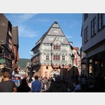
- Already the people of pre- and early history knew about the strategic importance of the bottleneck at the Mainknie between Odenwald and Spessart and erected mighty ring walls on the Greinberg above Miltenberg and on the Bürgstadt mountain.. Around 155 AD, the Romans here joined the almost straight south to the ´front Limes´ on the Main.. In the protection of the Mildenburg (built around 1200), the city of Miltenberg developed.. It was first mentioned in writing in 1237.. From about 1379, the two city towers, the Mainzer and the Würzburger Tor, limited the narrow and long stretched today´s old town area to the west and east. <9> Until 1803 Miltenberg belonged to Kurmainz.. This manifests itself to this day in the Mainz wheel in the coat of arms.. <9> From Miltenberg also come the so-called Heunensäulen, which were intended for the construction of the Mainz Cathedral.. In the middle of the Mainz Cathedral Square stands today one of these Heunesäulen with a corresponding billboard.. <9> Miltenberg has a historic old town, which has numerous half-timbered houses.. In the years 1912 and 1955 Miltenberg acquired land on the right side of the Main to expand the city.. Mildenburg has been owned by the city of Miltenberg since 1979.. <9> Here you can find more about <1001> Miltenberg} <9> <9> <994/1807442> <994/1807443> <994/1807444>
1617086 - The tour already starts in Miltenberg am Main.. The Main has meandered from Wertheim to Miltenberg between Odenwald and Spessart.. He offers an excellent taste of the Tauber Valley on this route.. <9> <9> Hiking and nature lovers, cyclists and the physically active, health-conscious, art lovers and gourmets are attracted by the ´LOVELY TAUBERTAL´ almost magical.. With the typical charm of its landscape, characterized by magnificent buildings and cultural monuments embedded in the landscape, the holiday region on Main and Tauber offers peace, but also a lot of activity and conviviality for recreation.. <9> <9> There are many <1001> info here
1616624 - Route 7: older main line <9> Miltenberg - Rehberg <9> Province: Germania superior <9> <9> Name;. <9> Location, <9> Coordinates <9> Description <9> <9> <9> Fort Miltenberg-Ost, <9> 63897 Miltenberg, <9> N49.. 70556, E9.. 26162 <9> Excavations in 1912 have proven the fort.. There is no sign of it today.. <9> <9> Watchtower Wp 07/01, <63> 63897 Miltenberg, <9> N49.. 70312, E9.. 26665 <9> No traces visible <9> <9> Wachturm Wp 07/02, <9> 63897 Miltenberg, <9> N49.. 70004, E9.. 26999 <9> No evidence of traces <9> <9> Wachturm Wp 07/03, <9> 63897 Miltenberg, <9> N49.. 6969, E9.. 27441 <9> No evidence of obstruction <9> <9> Wachturm Wp 07/04, <9> 63897 Miltenberg, <9> N49.. 69332, E9.. 28016 <9> No evidence of obstruction <9> <9> Watchtower Wp 07/05, <9> 63897 Miltenberg, <9> N49.. 69043, E9.. 28411 <9> No traces visible <9> <9> Wachturm Wp 07/06, <9> 63897 Miltenberg, <9> N49.. 68833, E9.. 28722 <9> The meaning of the two stone buildings that were found next to the tower is still unclear.. <9> <9> Watchtower Wp 07/07, <9> 63897 Miltenberg, <9> N49.. 68686, E9.. 29039 <9> No traces visible <9> <9> Wachturm Wp 07/08, <9> 63897 Wenschdorf, <9> N49.. 68361, E9.. 29065 <9> No evidence of traces <9> <9> Wachturm Wp 07/09, <9> 63897 Wenschdorf, <9> N49.. 67997, E9.. 29031 <9> No traces visible <9> <9> Wachturm Wp 07/10, <9> 63897 Wenschdorf, <9> N49.. 67711, E9.. 29018 <9> No evidence of traces <9> <9> Watchtower Wp 07/11, <9> 63897 Wenschdorf, <9> N49.. 67342, E9.. 28966 <9> Only a shallow hill visible <9> <9> Watchtower Wp 07/12, <9> 63897 Wenschdorf, <9> N49.. 67007, E9.. 28962 <9> Only slight traces visible 16386 <9> <9> Watchtower Wp 07/13, <9> 74934 Reichartshausen, <9> N49.. 66417, E9.. 28917 <9> A stone outbuilding was found here.. <9> <9> Watchtower Wp 07/14, <9> 74934 Reichartshausen, <9> N49.. 66183, E9.. 29273 <9> No traces visible <9> <9> Watchtower Wp 07/15, <9> 74934 Reichartshausen, <9> N49.. 65861, E9.. 29806 <9> Only slight traces visible <9> <9> Wachturm Wp 07/16, <9> 74934 Reichartshausen, <9> N49.. 65472, E9.. 30194 <9> Only slight traces visible <9> <9> Watchtower Wp 07/17, <9> 74934 Reichartshausen, <9> N49.. 65341, E9.. 30432 <9> Only slight traces visible <9> <9> Wachturm Wp 07/18, <9> 74731 Walldürn Reinhardsachsen, <9> N49.. 64944, E9.. 30934 <9> No evidence of traces <9> <9> Wacht tower Wp 07/19, <9> 74731 Walldürn-Gottersdorf <9> N49.. 64602, E9.. 31449 <9> No evidence of obstruction <9> <9> Watchtower Wp 7/20, <9> 74731 Walldürn Reinhardsachsen, <9> N49.. 64155, E9.. 32037 <9> No evidence of traces <9> <9> Watchtower Wp 7/21, <9> 74731 Walldürn Reinhardsachsen, <9> N49.. 63932, E9.. 32376 <9> No evidence of traces <9> <9> Watchtower Wp 7/22, <9> 74731 Walldürn Reinhardsachsen, <9> N49.. 63585, E9.. 32809 <9> No evidence of traces <9> <9> Kleinkastel Haselburg, <9> 74731 Walldürn Reinhardsachsen, <9> N49.. 63333, E9.. 3303 <9> <9> <9> Watchtower Wp 7/23 Gesengte Hecken, <7> 74731 Walldürn-Gerolzahn, <9> N49.. 63111, E9.. 33472 <9> No evidence of traces <9> <9> Wacht tower Wp 7/24 Tannenwald, <9> 74731 Walldürn-Gerolzahn, <9> N49.. 6275, E9.. 34 <9> Visible is a rubble mound with a diameter of 6 m and a height of 0.9 m.. In 1897 the foundation remains were secured.. <9> <9> Watchtower Wp 7/25 In the Long Birches, <9> 74731 Walldürn-Gerolzahn, <9> N49.. 62444, E9.. 34389 <9> No evidence of traces <9> <9> Watchtower Wp 7/26 Amorbacher Weg, <9> 74731 Glashofen-Neusaß, <9> N49.. 6218, E9.. 34762 <9> No evidence of traces <9> <9> Wacht tower Wp 7/27 Schweinshecke, <9> 74731 Walldürn-Glashofen, <9> N49.. 61889, E9.. 35111 <9> No traces visible <9> <9> Wacht tower Wp 7/28 Mühläcker, <9> 74731 Walldürn-Glashofen, <9> N49.. 61535, E9.. 35608 <9> No traces visible <9> <9> Watchtower Wp 7/29 In the clover, <9> 74731 Walldürn-Glashofen, <9> N49.. 61306, E9.. 35833 <9> No traces visible <9> <9> Watchtower Wp 7/30 At the big wood, <9> 74731 Walldürn-Glashofen, <9> N49.. 60972, E9.. 36222 <9> No evidence of traces <9> <9> Steinernes Haus, <9> 74731 Walldürn-Glashofen, <9> N49.. 60556, E9.. 36639 <9> Excavations in 1880 revealed the foundations of a house.. <9> Rectangular plan, 8.1 mx 6.8 m.. <9> <9> Watchtower Wp 7/31, <7> 74731 Walldürn-Glashofen, <9> N49.. 60556, E9.. 36639 <9> The foundation walls with a rectangular plan of 4.7X4.9m have been preserved.. <9> <9> Wacht tower Wp 7/32 Großer Wald, <7> 74731 Walldürn-Glashofen, <9> N49.. 60194, E9.. 37028 <9> Completely destroyed for years, only earth deformations testify to the tower.. <9> <9> Watchtower Wp7 / 33 Lindig Nord, <9> 74731 Walldürn, <9> N49.. 59861, E9.. 37389 <9> The tower was restored in 1965 16399 <9> <9> Watchtower Wp 7/34 Taubenpfad, <9> 74731 Walldürn, <9> N49.. 5966, E9.. 37642 <9> No evidence of obstruction <9> <9> Watchtower Wp 7/35 Galgen, <9> 74731 Walldürn, <9> N49.. 59333, E9.. 37972 <9> Investigations took place in 1885.. 16400 <9> <9> Watchtower Wp 7/35 Lindig South, <9> 74731 Walldürn, <9> N49.. 59333, E9.. 37972 <9> No traces visible <9> <9> Wachturm Wp 7/36 Rotbild, <9> 74731 Walldürn, <9> N49.. 59057, E9.. 38294 <9> No traces visible <9> <9> Wachturm Wp 7/37 Old brick house, <9> 74731 Walldürn, <9> N49.. 5879, E9.. 38615 <9> No evidence of traces <9> <9> Watchtower Wp 7/38 Kern, <9> 74731 Walldürn, <9> N49.. 58493, E9.. 39015 <9> No traces visible <9> <9> Watchtower Wp 7/39 Long landmark, <9> 74731 Walldürn, <9> N49.. 58175, E9.. 39289 <9> No evidence of traces <9> <9> Kastel Alte Burg, <9> 74731 Walldürn, <9> N49.. 57833, E9.. 38694 <9> Only slight traces visible <9> <9> Roman Bath Walldürn, <9> 74731 Walldürn, <9> N49.. 57898, E9.. 38517 <9> Foundations of a Roman bath are partially reconstructed and preserved.. <9> <9> Watchtower Wp 7/40, <7> 74731 Walldürn, <9> N49.. 57624, E9.. 39114 <9> No evidence of obstruction <9> <9> Watchtower Wp 7/41, <9> 74731 Walldürn, <9> N49.. 57134, E9.. 38973 <9> No evidence of obstruction <9> <9> Watchtower Wp 7/42, <9> 74731 Walldürn, <9> N49.. 56809, E9.. 38861 <9> No evidence of obstruction <9> <9> Watchtower Wp 7/43, <9> 74731 Walldürn, <9> N49.. 56444, E9.. 38763 <9> No evidence of obstruction <9> <9> Watchtower Wp 7/44 Tannenbaum, <9> 74731 Walldürn, <9> N49.. 56024, E9.. 3863 <9> No evidence of obstruction <9> <9> Watchtower Wp 7/45, <9> 74731 Walldürn, <9> N49.. 55737, E9.. 38531 <9> No evidence of obstruction <9> <9> Watchtower Wp 7/46, <9> 74731 Walldürn, <9> N49.. 55473, E9.. 38449 <9> No evidence of obstruction <9> <9> Watchtower Wp 7/47, <9> 74731 Walldürn, <9> N49.. 55219, E9.. 38509 <9> No evidence of obstruction <9> <9> Watchtower Wp 7/48, <9> 74722 Buchen Hettingen, <9> N49.. 54889, E9.. 38611 <9> Completely destroyed by a heavy traffic accident <9> <9> Altheimer Straße.. <9> 74722 Booking Hettingen, <9> N49.. 54507, E9.. 38362 <9> not visible in the forest floor <9> <9> Kleinkastell Rehberg, also Hönehaus, <9> 74722 Buchen Hettingen, <9> N 49. 54278, E9.. 387 <9> The barrier is clearly visible and conserved.. <9> <9> Watchtower Wp 7/49, <9> 74722 Buchen Hettingen, <9> N49.. 54285, E9.. 38876 <9> No traces recognizable <9>
1750854


Video films of the place and surroundings


-
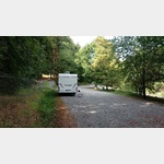
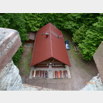
Motorhome place campsite Am Leinritt
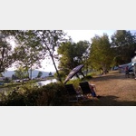
 63920 Großheubach Bavaria Germany
Pay for use site 24 Euro


")
")


open 1.April until 31.Oktober


Motorhome place Restaurant Weingut zur Bretzel
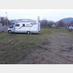
 63920 Grossheubach Bavaria Germany
Pay for use site 25 Euro


open 1.Januar until 31.Oktober

 Selected parking spaces
 | general parking lot
This car park is ideal for visiting the Engelberg monastery or sitting in the beautiful beer garden.
From here, hiking trails of different lengths start.
24 hour parking fee is 1.50. Unfortunately,. . . FURTHER . . .
From here, hiking trails of different lengths start.
24 hour parking fee is 1.50. Unfortunately,. . . FURTHER . . .
| general parking lotParkplatz Miltenberg Mainufer
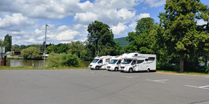 deutschland 63897 Miltenberg Jahnstraße
Parking right on the banks of the Main. Only from 5-10 p.m.
Closed from mid-August to mid-September due to a folk festival.
The place is closed if there is a risk of flooding.
Directions: A3/E35, . . . FURTHER . . .
| general parking lotParkplatz St2309
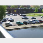 deutschland 63897 Miltenberg St2309
Large car park on both sides of the Main Bridge.
Paid parking time regulation with barrier system at the entrance.
Parking bays/spaces are marked in the usual car size.
 | Parking suitable for campers over 5 m
Parkplatz Springquelle
 deutschland 63897 Miltenberg Mainbullauer Strasse
 Hikers´ car park, overnight stays not permitted
Larger, partly shady hikers´ car park. The source is unfortunately separated by a fence.
 | Parking lot for hikers
deutschland Bürgstadt
 |
| deutschland 63933 Mönchberg
Selected sights
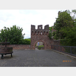
 | tower
Schnatterlochturm
 deutschland 63897 Miltenberg Klinge
Der Schnatterlochturm ist ein historischer Turm in Miltenberg, einer Stadt in Bayern, Deutschland. Der Turm wurde im 14. Jahrhundert als Teil der mittelalterlichen Stadtmauer errichtet und diente als . . . FURTHER . . .
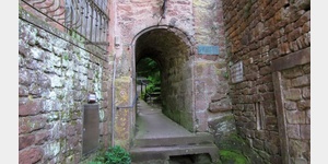
 | Castle
Clingenburg
 63911 Klingenberg Clingenburgstr.
The original Hohenstaufen castle has been destroyed down to the archway and the massive foundations of the keep.
Today there is a restaurant with a dominant window front facing the valley and a vi. . . FURTHER . . .
 | Sightseeing
Esskastanien-Lehrpfad
deutschland 63911 Klingenberg am Main
The Klingenberger sweet chestnut nature trail offers all those interested the opportunity to find out about the cultural and historical background of the sweet chestnut on 13 information boards, as we. . . FURTHER . . .
The Klingenberger sweet chestnut nature trail offers all those interested the opportunity to find out about the cultural and historical background of the sweet chestnut on 13 information boards, as we. . . FURTHER . . .
 | Hiking
Wanderung von Klingenberg nach Erlenbach
Deutschland 63911 Klingenberg am Main
Hike from Klingenberg to Erlenbach through the vineyards and back. At the beginning it goes to the village of Klingenberg and then into the vineyards. On the way back it gets a bit exciting and you sh. . . FURTHER . . .
Hike from Klingenberg to Erlenbach through the vineyards and back. At the beginning it goes to the village of Klingenberg and then into the vineyards. On the way back it gets a bit exciting and you sh. . . FURTHER . . .
 | Cultural History
Templerhaus
 Deutschland 63916 Amorbach Bädersweg 7
It is one of the oldest half-timbered houses in Germany, built in 1291. The substructure is probably around 100 years older.
Opening times:
from May to October Wednesday 4.30 p.m. - 5.30 p.m.
Selected service points
 | car wash
Hobby Wasch Park
deutschland 63897 Miltenberg
 | Motorhome service
Camping Caravan Werkstatt
deutschland 63937 Weilbach Weckbacher Straße
Selected gastronomy
 | Guest House
Wanderheim Klingenberg
 deutschland 63911 Klingenberg am Main Kastanienweg
Hiking home with overnight accommodations open on weekends, public holidays and every 2nd Wednesday, home-style cooking, beautiful location in the forest above Klingenberg directly at the lookout tower
| Guest HouseGasthaus zum Riesen
 Deutschland 63897 Miltenberg Hauptstr. 99
one of the oldest inns in Germany with a great tradition
2001 extensively renovated and reopened, management Brauhaus Faust
| Guest HouseWeingut Lutz - Häckerstube
deutschland 63911 Klingenberg am Main Ludwigstraße
large, cozy Häckerstube with lots of space and tasty, rustic cuisine
large, cozy Häckerstube with lots of space and tasty, rustic cuisine
 | eMail
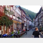 deutschland 63897 Miltenberg, Miltenberg-Nord | eMail
Restaurant McDonalds
deutschland 63927 Bs¼rgstadt Am Stadtweg
| eMaildeutschland 63911 Klingenberg a. Main, Trennfurt Höhbergstrase
| eMaildeutschland 63911 Klingenberg a. Main, Trennfurt Rathausstrase
 | Cafe
Clingenburg
deutschland 63911 Klingenberg am Main Sonnenweg
motorhome places Grossheubach in these books
General Pois
 | church
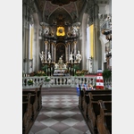
St. Jakobus
Deutschland 63897 Miltenberg Pfarrgasse 2
The church is Catholic parish church of Miltenberg. It is dedicated to the Apostle James the Elder.
The church was built in a classical style as a three-aisled gallery pseudo-basilica. It has a th. . . FURTHER . . .
The church is Catholic parish church of Miltenberg. It is dedicated to the Apostle James the Elder.
The church was built in a classical style as a three-aisled gallery pseudo-basilica. It has a th. . . FURTHER . . .
 | Kapelle
Amorsbrunn
Deutschland 63916 Amorbach Amorsbrunn 2
Chapel Amorsbrunn in Otterbachtal
Gaugraf Ruthard brought Irish wandering monks to the country in the 8th century to Christianize the Spessart.
A Romanesque church was built over the spring in . . . FURTHER . . .
Chapel Amorsbrunn in Otterbachtal
Gaugraf Ruthard brought Irish wandering monks to the country in the 8th century to Christianize the Spessart.
A Romanesque church was built over the spring in . . . FURTHER . . .
| churchkath. Kirche St Gangolf
 Deutschland 63916 Amorbach Kirchplatz
 The Catholic Church of St Gangolf, decorated in the baroque style, is located in the old town of Amorbach. It is not as well known as the abbey church there, but it is still worth a visit.
 | Castle
Schloss Laudenbach
Deutschland 63925 Laudenbach Dorfstraße 1
Josepha von Eyb, the widow of General Field Marshal Reichart von Fechenbach had the palace built in 1717. Today it is owned by the von Löwenstein family.
Josepha von Eyb, the widow of General Field Marshal Reichart von Fechenbach had the palace built in 1717. Today it is owned by the von Löwenstein family.
| churchSt. Josef in Mechenhard
Deutschland 63906 Erlenbach Mechenharder Straße 152
The church was built in 1752. In 1962 a major renovation took place.
Noteworthy are:
The altar mural by Lukas Gastl
A 16-lamp chandelier
The church was built in 1752. In 1962 a major renovation took place.
Noteworthy are:
The altar mural by Lukas Gastl
A 16-lamp chandelier