motorhome places Golling Austria
Europe´s bigest motorhome-portal
from motorhome drivers for motorhome driver
start
motorhome places Golling Austria
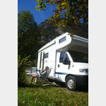
Motorhome place Aqua Salza
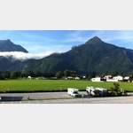
 5440 Golling Salzburg Austria
Pay for use site 13 Euro


")


open Januar until Dezember


Golling, Pictures of the city and surroundings


Golling, Pictures and general information
 Selected parking spaces
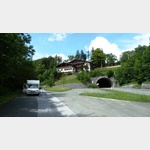
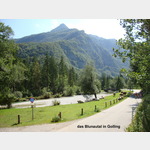
 | Parking suitable for campers over 5 m
Parkplatz Blumtaustrasse
 österreich 5440 Golling an der Salzach Blumtaustrasse
Parking lot at the beginning of the beautiful Bluntau valley, (must go for a walk or hike) in the summer is charged, otherwise free,
is good for resting on the A 10, AB in the front area can be heard at night
Arrival: from the A 10 to Golling then over the bridge to Beginning of the Bluntau Valley
Selected service points
 | Ladestation
Ionity Golling
österreich 5440 Lanzen
Selected gastronomy
 | Guest House
Gasthof Bärenwirt
Österreich 5440 Golling an der Salzach Bluntaustraße
 | McDonald
McDonald
österreich 5440 Golling an der Salzach
Selected sights
 | Hiking
SalzAlpenSteig 12, Golling - Scheffau
Österreich 5440 Golling an der Salzach
SalzAlpenSteig
The hiking trail leads over 233 km from Lake Chiemsee to the Dachstein.
Walking past the old salt deposits, hikers learn a lot about salt mining and processing. The unique landscape is good for the soul. There are also numerous other sights along the way.
Between the lowest point at 457m and the highest at 1662m, there is a total of over 10,000m of ascent.
In many places, side paths offer the opportunity to plan your own stages.
One suggestion are these 18 stages.
Prien am Chiemsee Grassau, 19.8 km
Grassau Brachtalm, 18.3 km
Brachtalm Bergen, 9. 8 km
Bergen Ruhpolding, 15.9 km
Ruhpolding Inzell, 14.9 km
Inzell - Bad Reichenhall, 22, 2 km
Bad Reichenhall Bischofswiesen, 16, 3 km
Bischofswiesen Ramsau, 18, 4 km
Ramsau Königssee, 18,
| HikingSalzAlpenSteig 13, Scheffau - Abtenau
Österreich 5440 Scheffau am Tennengebirge
SalzAlpenSteig
The hiking trail leads over 233 km from Lake Chiemsee to the Dachstein.
Walking past the old salt deposits, hikers learn a lot about salt mining and processing. The unique landscape is good for the soul. There are also numerous other sights along the way.
Between the lowest point at 457m and the highest at 1662m, there is a total of over 10,000m of ascent.
In many places, side paths offer the opportunity to plan your own stages.
One suggestion are these 18 stages.
Prien am Chiemsee Grassau, 19.8 km
Grassau Brachtalm, 18.3 km
Brachtalm Bergen, 9. 8 km
Bergen Ruhpolding, 15.9 km
Ruhpolding Inzell, 14.9 km
Inzell - Bad Reichenhall, 22, 2 km
Bad Reichenhall Bischofswiesen, 16, 3 km
Bischofswiesen Ramsau, 18, 4 km
Ramsau Königssee, 18,
| HikingSalzAlpenSteig 11, Bad Dürrnberg - Golling
Österreich 5422 Hallein
SalzAlpenSteig
The hiking trail leads over 233 km from Lake Chiemsee to the Dachstein.
Walking past the old salt deposits, hikers learn a lot about salt mining and processing. The unique landscape is good for the soul. There are also numerous other sights along the way.
Between the lowest point at 457m and the highest at 1662m, there is a total of over 10,000m of ascent.
In many places, side paths offer the opportunity to plan your own stages.
One suggestion are these 18 stages.
Prien am Chiemsee Grassau, 19.8 km
Grassau Brachtalm, 18.3 km
Brachtalm Bergen, 9. 8 km
Bergen Ruhpolding, 15.9 km
Ruhpolding Inzell, 14.9 km
Inzell - Bad Reichenhall, 22, 2 km
Bad Reichenhall Bischofswiesen, 16, 3 km
Bischofswiesen Ramsau, 18, 4 km
Ramsau Königssee, 18,
| HikingKuchl - Nesslangeralm - Kuchl
Österreich 5431 Kuchl
A circular hiking trail on the Salzalpensteig.
Length: 12 km
Highest point: 1295 m
Lowest point: 457 m
A circular hiking trail on the Salzalpensteig.
Length: 12 km
Highest point: 1295 m
Lowest point: 457 m
| HikingSalzAlpenTour - Jochalm - Golling
Österreich 5440 Golling an der Salzach
SalzAlpenTour - Jochalm - Golling
length: 11.31 km
highest point: 1170 m
lowest point: 505 m
SalzAlpenTour - Jochalm - Golling
length: 11.31 km
highest point: 1170 m
lowest point: 505 m
 | Landscape
Salzachklamm
österreich 5440 Golling an der Salzach B159
from here you can comfortably walk into the Salzach Gorge, which is well worth seeing
from here you can comfortably walk into the Salzach Gorge, which is well worth seeing
 | Bridge
Bruecke Salzach Kuchl
österreich 5431 Kuchl Salzachstraße
 | Cave
Hubertusgrotte
 | church
Filialkirche Maria Brunneck
österreich 5440 Golling an der Salzach Luegwinkl
 | waterfall
Gollinger Wasserfall
österreich 5440 Torren Wasserfallstraße
motorhome places Golling in these books
General Pois
 |
|  österreich 5440 Golling an der Salzach B159
 | ätere Stadtgalerie
Golling an der Salzach
 österreich 5440 Gemeinde Golling an der Salzach Markt
 choose another country