
Europe´s most comprehensive mobile home portal
Over 15 years of experience and quality
by camper drivers for camper drivers


Over 15 years of experience and quality
by camper drivers for camper drivers
Kunst am Weg, Wege zur Kunst, Freudenstadt
Tour / hiking / bike / ski / Skulpturenwege
These art objects stand on the tour of the city.
Lumina, René Dantes, forecourt of the Stadtbahnhof
Freudenstädter Glockenspiel, Martin-Luther-Platz
Stele, Tobias Kammerer, Leonhardtstraße
We stay together, Mike Masedza, Zimbabwe, pedestrian zone Forststraße
Zaubergarten, Leifur Breidfjörd from Iceland, pedestrian zone Forststraße
Steinbewachsenes Haus , Wolf Bröll, at the Rathausturm
Rathausbrunnen, Christian Wälde, Oberer Marktplatz
Neptunbrunnen, Joh. Jakob Reich, Oberer Marktplatz
Venus, David Fahrner, Marktplatzmitte
Genesis, Fluss-Sandstein, Sonja Braun, Oberer Marktplatz
Scheue Frau, Lazarus Takawira aus Zimbabwe, Oberer Marktplatz, in front of the Kreissparkasse
Schwarzwldbrunnen, Hannes Lohrer, Im Oberen Marktplatzeck
Schwarzes Wasser, Wolf Bröll, Reichsstrasse pedestrian zone
Heliopolis, Wolf Bröll,
Description of the tour
Number of tour points = 106
Total length of the tour = 4.98 km
Height difference = 73.54 m
Minimum height = 724.13 m
Maximum height = 797.67 m
contour line:

ADDRESS
72250 Freudenstadt
Click for interactive map
..
Images from Poi and starting point surroundings
Videos about the starting point
.
Routes and books with this POI
Schwarzwald Rundreise
.
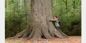
Things worth seeing around the starting point
Polizei Direktion
Freudenstadt Police Department[ click for more information ]
Experimenta Freudenstadt
Adventure museum for the whole family[ click for more information ]
Panoramabad
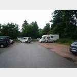
 Official parking space of the city on notice of the tourist office
usable 1 January - 31 December
[ click for more information ]
Kepler Gymnasium
Kepler Gymnasium Freudenstadt[ click for more information ]
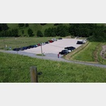
PKW Platz
 Day parking for a city tour.
[ click for more information ]
Shell
Shell petrol station in Freudenstadt[ click for more information ]
Friedrichsturm
In 1899 the 25 m high viewing tower was built on the Kienberg.[ click for more information ]
Gleitschirm-Startplatz Ost
Other: 72270 Baiersbronn, Sankenbachstrasse: East paragliding launch site[ click for more information ]
Gleitschirm-Startplatz Nord
Other: 72270 Baiersbronn, Reuteweg: North paragliding launch site[ click for more information ]
Gleitschirm-Startplatz (Übungshang)
Other: 72270 Baiersbronn, Reuteweg: Paragliding launch site (practice slope)[ click for more information ]
Parkplatz Sankenbachtal Rotwildgehege
 Very spacious parking lot for the Baiersbronn chairlift, which is totally quiet at night.
 [ click for more information ]
Lift Stöckerkopf
2211288_Beschreibung[ click for more information ]
Gleitschirm-Landeplatz
other: 72270 Baiersbronn, Sankenbachstraße: paragliding landing site[ click for more information ]
Sankenbachsteig
The path begins at the chairlift car park (the chairlift is no longer in operation) and leads from the chairlift car park to the game reserve.[ click for more information ]
Vogteiturm
The observation tower is 35 m high.[ click for more information ]
Flößerpfad Kinzigtal
In the footsteps of the old raftsmen[ click for more information ]
Aussichtsturm
The Black Forest Association built the observation tower on the 760 m high Rinkenber in 1914.[ click for more information ]
Copyright © 2023 - meinwomobuch.com
listed in the mobile home parking space database of meinwomo
listed in the mobile home parking space database of meinwomo