Moemlingen Germany
Europe´s bigest motorhome-portal
from motorhome drivers for motorhome driver
start
Moemlingen, Information and images
- Route 10: older Odenwald line / Neckar-Odenwald-Limes <9> Wörth am Main - Bad Wimpfen <9><9> <9> Name; <9> Location, <9> Coordinates<9> Description<9> <9> Numeruskastell Wörth; <9> 63939 Wörth a. Main, <9> N49. 8013, E9. 14474 <9> Only faint traces of the ground can be seen. <9> <9> Watchtower WP 10/1 Moorrain <9> 63939 Wörth a. Main, <9> Suspected but not proven <9> <9> Watchtower WP 10/2 Auf dem Schneeberg <9> 63939 Wörth a. Main, <9> Assumed but not proven <9> <9> Watchtower WP 10/3 in the gate <9> 64750 Seck walls, <9> Assumed but not proven <9> <9> Numerus fort Fort Seckmauern; <9> 64750 Seck walls, <9> N49. 79903, E9. 117363 <9> hardly any traces <9> <9>Watchtower WP 10/4 by the damp wall <9> 64750 Seck walls, <9> Suspected but not proven <9> <9> Watchtower WP 10/5 on the Seckmaurer Höhe <9> 64750 Seck walls, <9> Today is only to see a pile of rubble. The square tower had an edge length of 6.8 m. <9> <9> Steinturm Wp 10/6 Im Hannsbatzenfeld <9> 64750 Seckmauern, <9> N49. 79111, E9. 09861 <9> The stone tower, 5.0x5.5m, could only be confirmed in 2007. <9> <9> Watchtower Wp 10/7 Im Hoffeld <9> 64750 Lützelbach, <9> N49. 78417, E9. 09361 <9> Apart from a few stones, nothing can be seen in the agricultural area. <9> <9> Numerus fort Lützelbach; <9> 64750 Lützelbach <9> N49. 77944, E9. 08861 <9> There are still clear traces <9> <9> Wood and stone tower Wp 10/8 Im Lützelbacher Bannholz <9> 64750 Haingrund, <9> N49. 77167, E9. 08667 <9> There are still clear traces <9> <9> Wooden and stone tower Wp 10/9 Im Breitenbrunner Bannholz <9> 64750 Breitenbrunn, <9> N49. 76639, E9. 08444 <9> There are still clear traces <9> <9> Small fort Windlücke; <9> 64750 Breitenbrunn, <9> N49. 76167, E9. 08389 <9> It is an invisible ground monument <9> <9> Wooden and stone tower Wp 10/10 In der Klinge <9> 64750 Lützelbach, <9> N49. 75778 E9. 08083 <9> The tower site is partially reconstructed <9> <9> Wooden and stone tower Wp 10/11; Sellenplatte, <9> 64750 Lützelbach, <9> N49. 74778, E9. 08028 <9> The foundation walls are partially preserved <9> <9>Wooden tower Wp 10/12 In den Dickhecken <9> 64720 Michelstadt, <9> N49. 74139, E9. 08222 <9> There are clear traces of the ground <9> <9> Wooden tower Wp 10/13 In den Erlen <9> 64720 Michelstadt, <9> N49. 73611, E9. 08417 <9> There are clear traces of the ground <9> <9> Hainhaus numerus fort; <9> 64720 Michelstadt, <9> N49. 73278, E9. 08319 <9> There are clear traces of the ground <9> <9> Watchtower Wp 10/14 on the Döllchenschneise <9> 64720 Michelstadt <9> N49. 72639, E9. 085 <9> The building material was probably used elsewhere. <9> <9> Wooden tower Wp 10/15 in the upper Haspel <9> 64720 Michelstadt, <9> N49. 71972, E9. 08597 <9> There is an information point in the reconstructed tower. <9> <9>Watchtower Wp 10/16 near Vielbrunn <9> 64720 Michelstadt, <9> N49. 71361, E9. 08583 <9> It was not until 2006 that the tower location could be confirmed by geophysical prospecting methods. <9> <9> Wooden tower Wp 10/17 In den Heumatten <9> 64720 Michelstadt, <9> N49. 70639, E9. 08417 <9> The wooden tower can still be seen <9> <9> Wooden tower Wp 10/18 Im Strichherrenwald <9> 64720 Michelstadt, <9> N49. 70222, E9. 08278 <9> Traces of the wooden tower are clearly visible <9> <9> Wooden tower Wp 10/19 An der Lichten Platte <9> 64720 Michelstadt, <9> N49. 69333, E9. 08333 <9> The visible tower is in the inaccessible Graeflich Erbachischen Eulbacher Wildpark <9> <9> Wooden tower Wp 10/20 Am Kutschenweg <9> 64720 Michelstadt, <9> N49. 68778, E9. 08167 <9> The visible tower point is in the inaccessible Graeflich Erbachischen Eulbacher Wildpark <9> <9> Numeruskastell Eulbach; <9> 64720 Michelstadt, <9> N49. 68, E9. 07792 <9> Faint traces of ground are still recognizable <9> <9> Wooden and stone tower Wp 10/21 In der Heumatte <9> 64711 Erbach <9> The tower site was not archaeologically examined <9> <9> Wooden tower Wp 10 / 22; Vogelherdschlag, <9> 64720 Michelstadt, <9> N49. 66528, E9. 07611 <9> The foundation walls of the rectangular tower, 5.4x5.45m, were partially reconstructed <9> <9> Watchtower Wp 10/23 Auf der Höhe 535.5 <9> 64720 Michelstadt, <9> Assumed but not proven <9 > <9> Watchtower Wp 10/24 Im Würzberger Feld; <9> 64720 Michelstadt, <9> Suspected but not proven <9> <9>Wooden tower Wp 10/25 on the Red Buckel ´<9> 64720 Michelstadt, <9> N49. 64278, E9. 07 <9> The foundation walls were reconstructed <9> <9> Numerus fort, Würzberg Castle; <9> 64720 Michelstadt, <9> N49. 63417, E9. 07528 <9> Parts of the fort were conserved by the RLK <9> <9> Wooden tower Wp 10/26 Im Sack <9> 63931 Kirchzell, <9> N49. 62806, E9. 08111 <9> Faint traces of the ground are still recognizable <9> <9> Wooden tower Wp 10/27 Im Gescheid <9> 64711 Erbach, <9> N49. 61917, E9. 07972 <9> Faint traces of the ground can still be seen <9> <9> Wooden and stone tower Wp 10/28 in the upper Seeschlag <9> 63931 Kirchzell, <9> N49. 61167, E9. 08 <9> Faint traces of soil are still recognizable <9> <9> Wooden tower Wp 10/29 Im lower Seeschlag <9> 63931 Kirchzell,<9> N49. 60167, E9. 0825 <9> Faint traces of soil are still recognizable <9> <9> Wooden and stone tower Wp 10/30 Bird tree hedges; <9> 63931 Kirchzell, <9> N49. 59453, E9. 08432 <9> parts were reconstructed <9> <9> watchtower Wp 10/31 Im Saufeld; <9> 63931 Kirchzell, <9> N49. 58555, E9. 08222 <9> Suspected but not proven <9> <9> Numeruskastell Hesselbach; <9> 64754 Hesseneck, <9> N49. 57625, E9. 09056 <9> Faint traces can still be seen <9> <9> Watchtower Wp 10/32 height hump; <9> 64754 Hesseneck, <9> N49. 5706, E9. 09889 <9> Only a heap of rubble is evidence of the tower <9> <9> Watchtower Wp 10/33 Auf dem Kahler Buckel <9> 64754 Hesseneck, <9> N49. 56409, E9. 09944 <9> Parts of the foundation walls were reconstructed <9> <9> Limes wall Schlossau <9> <9> Zwing small fort; <9> 69427 Mudau, <9> N49. 56111, E9. 10111 <9> It is a marked ground monument <9> <9> Watchtower Wp 10/34 In the Hohen Wald also Hohwald <9> 69427 Mudau, <9> N49. 55806, E9. 10306 <9> Foundation walls partially reconstructed <9> <9> <9> Watchtower Wp 10/35 Am Klosterwald <9> 69427 Mudau, <9> N49. 55472, E9. 10611 <9> Foundation walls partially reconstructed <9> <9> Watchtower Wp 10/36 Am Fischerpfad <9> 69427 Mudau, <9> N49. 55298, E9. 11519 <9> Foundation walls partially reconstructed <9> <9> Seitzenbuche small fort; <9> 69427 Mudau, <9> N49. 55061, E9. 12243 <9> It is a marked ground monument <9> <9> Watchtower Wp 10/37 Schneidershecke; <9> 69427 Mudau, <9>N49. 55, E9. 12889 <9> Foundation walls partially reconstructed <9> <9> Watchtower Wp 10/38 Am Rotkreuz <9> 69427 Mudau, <9> No visible traces <9> <9> Numeruskastell Schloßau; <9> 69427 Mudau, <9> N49. 54056, E9. 14944 <9> Hardly visible bumps <9> <9> Watchtower Wp 10/39 Im Striet; <9> 69427 Mudau, <9> suspected, not proven <9> <9> Watchtower Wp 10/40 Am Galmbacher Weg; <9> 69427 Mudau, <9> presumed, not proven <9> <9> watchtower Wp 10/41; In the Heunenhaus; <9> 69427 Mudau, <9> No visible traces <9> <9> Watchtower Wp 10/42; In the Säubaumack; <9> 69427 Mudau, <9> In 1883 a stone tower with an edge length of 5.6 m was found <9> <9> Oberscheidental cohort fort; <9> 69427 Mudau, <9> N49.50583, E9. 15294 <9> Building remains (Porta principalis dextra) and traces of terrain <9> <9> Watchtower Wp 10/43 Am Neckarweg; <9> 69427 Mudau, <9> suspected, not proven <9> <9> watchtower Wp10-44 Hönen- or Heunenbuckel near Oberscheidental; <9> 74838 Limbach, <9> N49. 48333, E9. 14999 <9> A mound of rubble is evidence of a stone tower, 8.1x8.3m. <9> <9> Watchtower Wp 10/45 Im Weißmauerfeld; <9> 74838 Limbach, <9> Some worked stones were found in 1970 <9> <9> Watchtower Wp 10/46 Auf dem Dreispitz; <9> 74838 Limbach, <9> A stone tower that was excavated in 1850 <9> <9> Watchtower Wp 10/47 Im Gewann Schlagfeld; <9> 74838 Limbach, <9> suspected, not proven <9> <9> Small fort Robern / Hönehaus WP 10/48; <9> 74864 Fahrenbach, <9>N49. 46583, E9. 16028 <9> parts of the wall were preserved <9> <9> watchtower Wp 10/49 in the old field; <9> 74864 Fahrenbach, <9> Completely destroyed during road construction work around 1872. <9> <9> Watchtower Wp 10/50 Brenneisenäcker; <9> 74864 Fahrenbach, <9> suspected but not proven. <9> <9> Watchtower Wp 10/51 on the Roberner Höhe; <9> 74864 Fahrenbach, <9> <9> Small fort Trienz, WP 10/52; <9> 74864 Fahrenbach, <9> N49. 44056, E9. 16417 <9> The fort area is completely built over today <9> <9> Watchtower Wp 10/53 Roter Buckel; <9> 74864 Fahrenbach, <9> The tower was not excavated. <9> <9> Watchtower Wp 10/54 Mühlwegschlag; <9> 74864 Fahrenbach, <9> At this point there were 2 wooden and 1 stone towers. <9> <9>Watchtower Wp 10/55 Fahrenbacher Buchwald; <9> 74864 Fahrenbach, <9> <9> Watchtower Wp 10/56 Tannengewann; <9> 74821 Sattelbach <9> During excavations around 1897, foundation walls measuring 5.5x5.5m were discovered. <9> <9> Watchtower Wp 10/57; <9> 74821 Sattelbach <9> Suspected at the schoolhouse in Sattelbach, but not proven. <9> <9> Watchtower Wp 10/58 Roter Brunnen; <9> 74821 Sattelbach <9> suspected but not proven. <9> <9> Watchtower Wp 10-59 in Schlag 8 near Sattelbach; <9> 74821 Sattelbach, <9> The foundation is difficult to find because it is completely overgrown. <9> <9> Watchtower Wp 10/60 Beat 9 of the Bürgerwald; <9> 74834 Elztal <9> Remnants of the foundations of a square stone tower of 5.5 m are still present. <9> <9>Watchtower Wp 10/61 Sallenäcker; <9> 74834 Elztal <9> suspected but not proven. <9> <9> Neckarburken numerus fort (east fort); <9> 74834 Elztal, <9> N49. 37778, E9. 17389 <9> Some of the foundations have been preserved <9> <9> Kastellbad Neckarburken <9> 74834 Elztal <9> N49. 37763, E9. 17203 <9> The bath belonging to the western fort is only partially preserved <9> <9> Neckarburken cohort fort (western fort); <9> 74834 Elztal, <9> N49. 37667, E9. 17028 <9> The fort area is completely built over. <9> <9> Watchtower Wp 10/62 Auf dem Masseldorn; <9> 74834 Elztal <9> N49. 3736, E9. 1746 <9> The RLK was able to prove the remains of the wall. <9> <9> Watchtower Wp 10-62a Eulberg near Neckarburken; <9> 74834 Elztal <9> N49. 3673, E9.1755 <9> Remnants of the wall could be detected. <9> <9> Watchtower Wp 10/63 In the street fields; <9> 74834 Elztal <9> N49. 3599, E9. 1752 <9> Excavations by the RLK found remains of the foundations of a stone tower with the dimensions 5.5x5.56m <9> <9> Watchtower Wp 10 / 63a <9> 74821 Mosbach <9> presumed, the exact location is not known <9> <9> Watchtower Wp 10/64 Knopfhof; <9> 74821 Mosbach <9> N49. 3562, E9. 1727 <9> There are no visible remains of the stone tower here. <9> <9> Watchtower Wp 10/65 Bergfeld; <9> 74821 Mosbach <9> N49. 3506, E9. 1731 <9> suspected, the exact location is not known <9> <9> Watchtower Wp 10 / 65a Im Thomasbrünnlein Flur <9> 74821 Mosbach <9> suspected, the exact location is not known <9> <9>Watchtower Wp 10/66 Im Stockbrunner Feld <9> 74821 Mosbach <9> presumed, the exact location is not known <9> <9> Watchtower Wp 10/67 Am stein (ernen) Tisch <9> 74821 Mosbach <9> presumed , the exact location is not known <9> <9> watchtower Wp 10/68 in northern Selbach <9> 74831 Gundelsheim <9> suspected, the exact location is not known <9> <9> watchtower Wp 10/69 Lerchenweg < 9> 74831 Gundelsheim <9> suspects, the exact location is not known <9> <9> Watchtower Wp 10 / 69a in southern Selbach <9> 74831 Gundelsheim <9> suspects the exact location is not known <9> <9 > Watchtower Wp 10-70 on the Hummelberg near Tiefenbach <9> 74831 Gundelsheim <9> N49. 3028, E9. 1889 <9> No visible archaeological finds <9> <9> Watchtower Wp 10 / 70a Foxtail <9>74831 Gundelsheim <9> suspects the exact location is not known <9> <9> Watchtower Wp 10/71 Schrammbiegelwald <9> 74831 Gundelsheim <9> suspects the exact location is not known <9> <9> Watchtower Wp 10 / 71a In den Rohräckern <9> 74831 Gundelsheim <9> suspected, the exact location is not known <9> <9> Watchtower Wp 10/72 In den Hühnergärten <9> 74831 Gundelsheim <9> suspected the exact location is not known <9> <9> watchtower Wp 10/73 Auf dem Heiligenrain <9> 74177 Bad Friedrichshall, <9> presumed, the exact location is not known <9> <9> watchtower Wp 10/74 in the field corridor level <9> 74177 Bad Friedrichshall, <9> presumed, the exact location is not known <9> <9> Watchtower Wp 10/75 Auf dem Dermuth <9> 74177 Bad Friedrichshall, <9>No visible archaeological finds <9> <9> Watchtower Wp 10/76 Auf dem Scherer <9> 74177 Bad Friedrichshall, <9> No visible archaeological finds <9> <9> Watchtower Wp 10/77 near Duttenberg; <9> 74177 Bad Friedrichshall, <9> suspected, the exact location is not known <9> <9> Uferkastell Duttenberg; <9> 74177 Bad Friedrichshall, <9> N49. 24638, E9. 19361 <9> No visible archaeological finds <9> <9> Watchtower Wp 10/78 near the clay pit; <9> 74177 Bad Friedrichshall, <9> presumed, the exact location is not known <9> <9> Watchtower Wp 10/79 An der Hohen Strasse; <9> 74177 Bad Friedrichshall, <9> suspected, the exact location is not known <9> <9> Wimpfen cohort fort in the valley; <9> 74206 Bad Wimpfen, <9> N49. 23139, E9. 17889 <9>completely built over <9> <9> Kochendorf small fort; <9> 74177 Bad Friedrichshall, <9> N49. 22569, E9. 22533 <9> <9> watchtower Wp 10/80 Riedäcker; <9> 74177 Bad Friedrichshall, <9> 1960 remains of foundations with a side length of 5.4 m were discovered here. <9> <9> watchtower Wp 10/81 panels; <9> 74177 Bad Friedrichshall, <9> 1964, remains of foundations with a side length of 8.2 m were discovered here. <9> <9>In 1964, remains of the foundations with a side length of 8.2 m were discovered here. <9> <9>In 1964, remains of the foundations with a side length of 8.2 m were discovered here. <9> <9>
1750735


Video films of the place and surroundings


-
Motorhome place Parkplatz an der Sporthalle
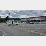
 63853 Mömlingen Germany
without charge


")

open Januar until Dezember


Motorhome place Parkplatz Mömlingen
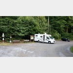 63853 Mömlingen Germany
without charge
open Januar until Dezember
 Selected parking spaces
 | general parking lot
Parkplatz Burg Breuberg
deutschland 64747 Rosenbach Burgstraße
| general parking lotKirchplatz
deutschland 63785 Obernburg am Main
| general parking lotSt. Anna Kapelle
deutschland 63785 Obernburg am Main
| general parking lotKochsmühle
deutschland 63785 Obernburg am Main
| general parking lotdeutschland 63820 Elsenfeld
 | Parking suitable for campers over 5 m
Parkplatz Burg Breuberg
deutschland 64747 Rosenbach Burgstrasse
| Parking suitable for campers over 5 mParkplatz, kein Wohnmobilverbot
deutschland 63868 Großwallstadt B 469
| Pia Fidelis
deutschland 63785 Obernburg am Main
| Festplatz
deutschland 63785 Obernburg am Main
 |
| Römermuseum
deutschland 63785 Obernburg am Main
Selected sights
 | Hiking
Fränkischer Rotwein Wanderweg II
deutschland 63762 Großostheim
Wir folgen dem unteren Eingangstor !Reischklinge!, um dann in einer linken Spitzkehre den gelb markierten Weg Nr. 1 zu erreichen.
Nach etwa 600 Metern kommen wir an einer Schutzhütte vorbei, die e. . . FURTHER . . .
Wir folgen dem unteren Eingangstor !Reischklinge!, um dann in einer linken Spitzkehre den gelb markierten Weg Nr. 1 zu erreichen.
Nach etwa 600 Metern kommen wir an einer Schutzhütte vorbei, die e. . . FURTHER . . .
 | Cultural History
BachgauMuseum
Deutschland 63762 Großostheim Marktplatz 1
Numerous exhibits explain the trades and agriculture in the 19th century. The museum is housed in the historical Nöthigsgut, a former cathedral fiefdom.
Opening hours:
Every Sunday and by appointment
Tel. : 06026/998499
Numerous exhibits explain the trades and agriculture in the 19th century. The museum is housed in the historical Nöthigsgut, a former cathedral fiefdom.
Opening hours:
Every Sunday and by appointment
Tel. : 06026/998499
| Cultural HistoryRömermuseum Obernburg am Main
Deutschland 63785 Obernburg Untere Wallstraße 29a
The history of the Limes is explained in the museum using finds from the Obernburg fort.
Opening hours:
Wed. Thu. 2.00 p.m. 4.00 p.m.
Sun. and public holidays 2 p.m. 5 p.m.
winter break from mid-December to mid-March.
The history of the Limes is explained in the museum using finds from the Obernburg fort.
Opening hours:
Wed. Thu. 2.00 p.m. 4.00 p.m.
Sun. and public holidays 2 p.m. 5 p.m.
winter break from mid-December to mid-March.
 | Castle
Burg Breuberg
64747 Breuberg, Neustadt Burgstraße
The castle was built in the 12th century and has been largely preserved. It is managed today by the administration of the State Palaces and Gardens of Hesse.
The 25 m high keep in the middle of the castle now serves as an observation tower.
The castle was built in the 12th century and has been largely preserved. It is managed today by the administration of the State Palaces and Gardens of Hesse.
The 25 m high keep in the middle of the castle now serves as an observation tower.
 | estuary
Mümling
The source is near Beerfelden, 49. 568256, 8. 97531. The Mümling has a length of 49 km.
Selected service points
 | AmazonHub
Amazon Hub Locker - julia
deutschland 63820 Elsenfeld Erlenbacher Straße 37
shell
shell
motorhome places Moemlingen in these books
General Pois
 | Sparkasse
Sparkasse
deutschland 63762 Grossostheim Kirchgasse
Mon-Fri 08:00-12:00, 14:00-17:00, » We 08:00-12:00, » Th 08:00-12:00, 14:00-18:00
Mon-Fri 08:00-12:00, 14:00-17:00, » We 08:00-12:00, » Th 08:00-12:00, 14:00-18:00
 | vet
| vetTierarzt
deutschland 63868 Groswallstadt
Tierärztliche Klinik für Pferde Niedernberger Strasse 9 Tel. 06022 20779
Tierärztliche Klinik für Pferde Niedernberger Strasse 9 Tel. 06022 20779
| vetTierarzt
deutschland 63762 Grosostheim Wallsts¤dter Weg
Pferdeklinik Großostheim Wendelinusweg 53 Tel. 0700 64 600 646
Pferdeklinik Großostheim Wendelinusweg 53 Tel. 0700 64 600 646
 | School
Schule
deutschland 63785 Obernburg am Main Oberer Neuer Weg
Johannes Obernburger elementary school in Obernburg am Main
Johannes Obernburger elementary school in Obernburg am Main
 | Other
sonstiges
Autohaus Bieger Renault
63820 Elsenfeld
Am Stachus
63820 Elsenfeld
Am Stachus