Obernburg-am-main Germany
Europe´s bigest motorhome-portal
from motorhome drivers for motorhome driver
start
Obernburg-am-main, Information and images
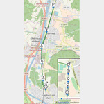
- Route 10: older Odenwald line / Neckar-Odenwald-Limes <9> Wörth am Main - Bad Wimpfen <9><9> <9> Name; <9> Location, <9> Coordinates<9> Description<9> <9> Numeruskastell Wörth; <9> 63939 Wörth a. Main, <9> N49. 8013, E9. 14474 <9> Only faint traces of the ground can be seen. <9> <9> Watchtower WP 10/1 Moorrain <9> 63939 Wörth a. Main, <9> Suspected but not proven <9> <9> Watchtower WP 10/2 Auf dem Schneeberg <9> 63939 Wörth a. Main, <9> Assumed but not proven <9> <9> Watchtower WP 10/3 in the gate <9> 64750 Seck walls, <9> Assumed but not proven <9> <9> Numerus fort Fort Seckmauern; <9> 64750 Seck walls, <9> N49. 79903, E9. 117363 <9> hardly any traces <9> <9>Watchtower WP 10/4 by the damp wall <9> 64750 Seck walls, <9> Suspected but not proven <9> <9> Watchtower WP 10/5 on the Seckmaurer Höhe <9> 64750 Seck walls, <9> Today is only to see a pile of rubble. The square tower had an edge length of 6.8 m. <9> <9> Steinturm Wp 10/6 Im Hannsbatzenfeld <9> 64750 Seckmauern, <9> N49. 79111, E9. 09861 <9> The stone tower, 5.0x5.5m, could only be confirmed in 2007. <9> <9> Watchtower Wp 10/7 Im Hoffeld <9> 64750 Lützelbach, <9> N49. 78417, E9. 09361 <9> Apart from a few stones, nothing can be seen in the agricultural area. <9> <9> Numerus fort Lützelbach; <9> 64750 Lützelbach <9> N49. 77944, E9. 08861 <9> There are still clear traces <9> <9> Wood and stone tower Wp 10/8 Im Lützelbacher Bannholz <9> 64750 Haingrund, <9> N49. 77167, E9. 08667 <9> There are still clear traces <9> <9> Wooden and stone tower Wp 10/9 Im Breitenbrunner Bannholz <9> 64750 Breitenbrunn, <9> N49. 76639, E9. 08444 <9> There are still clear traces <9> <9> Small fort Windlücke; <9> 64750 Breitenbrunn, <9> N49. 76167, E9. 08389 <9> It is an invisible ground monument <9> <9> Wooden and stone tower Wp 10/10 In der Klinge <9> 64750 Lützelbach, <9> N49. 75778 E9. 08083 <9> The tower site is partially reconstructed <9> <9> Wooden and stone tower Wp 10/11; Sellenplatte, <9> 64750 Lützelbach, <9> N49. 74778, E9. 08028 <9> The foundation walls are partially preserved <9> <9>Wooden tower Wp 10/12 In den Dickhecken <9> 64720 Michelstadt, <9> N49. 74139, E9. 08222 <9> There are clear traces of the ground <9> <9> Wooden tower Wp 10/13 In den Erlen <9> 64720 Michelstadt, <9> N49. 73611, E9. 08417 <9> There are clear traces of the ground <9> <9> Hainhaus numerus fort; <9> 64720 Michelstadt, <9> N49. 73278, E9. 08319 <9> There are clear traces of the ground <9> <9> Watchtower Wp 10/14 on the Döllchenschneise <9> 64720 Michelstadt <9> N49. 72639, E9. 085 <9> The building material was probably used elsewhere. <9> <9> Wooden tower Wp 10/15 in the upper Haspel <9> 64720 Michelstadt, <9> N49. 71972, E9. 08597 <9> There is an information point in the reconstructed tower. <9> <9>Watchtower Wp 10/16 near Vielbrunn <9> 64720 Michelstadt, <9> N49. 71361, E9. 08583 <9> It was not until 2006 that the tower location could be confirmed by geophysical prospecting methods. <9> <9> Wooden tower Wp 10/17 In den Heumatten <9> 64720 Michelstadt, <9> N49. 70639, E9. 08417 <9> The wooden tower can still be seen <9> <9> Wooden tower Wp 10/18 Im Strichherrenwald <9> 64720 Michelstadt, <9> N49. 70222, E9. 08278 <9> Traces of the wooden tower are clearly visible <9> <9> Wooden tower Wp 10/19 An der Lichten Platte <9> 64720 Michelstadt, <9> N49. 69333, E9. 08333 <9> The visible tower is in the inaccessible Graeflich Erbachischen Eulbacher Wildpark <9> <9> Wooden tower Wp 10/20 Am Kutschenweg <9> 64720 Michelstadt, <9> N49. 68778, E9. 08167 <9> The visible tower point is in the inaccessible Graeflich Erbachischen Eulbacher Wildpark <9> <9> Numeruskastell Eulbach; <9> 64720 Michelstadt, <9> N49. 68, E9. 07792 <9> Faint traces of ground are still recognizable <9> <9> Wooden and stone tower Wp 10/21 In der Heumatte <9> 64711 Erbach <9> The tower site was not archaeologically examined <9> <9> Wooden tower Wp 10 / 22; Vogelherdschlag, <9> 64720 Michelstadt, <9> N49. 66528, E9. 07611 <9> The foundation walls of the rectangular tower, 5.4x5.45m, were partially reconstructed <9> <9> Watchtower Wp 10/23 Auf der Höhe 535.5 <9> 64720 Michelstadt, <9> Assumed but not proven <9 > <9> Watchtower Wp 10/24 Im Würzberger Feld; <9> 64720 Michelstadt, <9> Suspected but not proven <9> <9>Wooden tower Wp 10/25 on the Red Buckel ´<9> 64720 Michelstadt, <9> N49. 64278, E9. 07 <9> The foundation walls were reconstructed <9> <9> Numerus fort, Würzberg Castle; <9> 64720 Michelstadt, <9> N49. 63417, E9. 07528 <9> Parts of the fort were conserved by the RLK <9> <9> Wooden tower Wp 10/26 Im Sack <9> 63931 Kirchzell, <9> N49. 62806, E9. 08111 <9> Faint traces of the ground are still recognizable <9> <9> Wooden tower Wp 10/27 Im Gescheid <9> 64711 Erbach, <9> N49. 61917, E9. 07972 <9> Faint traces of the ground can still be seen <9> <9> Wooden and stone tower Wp 10/28 in the upper Seeschlag <9> 63931 Kirchzell, <9> N49. 61167, E9. 08 <9> Faint traces of soil are still recognizable <9> <9> Wooden tower Wp 10/29 Im lower Seeschlag <9> 63931 Kirchzell,<9> N49. 60167, E9. 0825 <9> Faint traces of soil are still recognizable <9> <9> Wooden and stone tower Wp 10/30 Bird tree hedges; <9> 63931 Kirchzell, <9> N49. 59453, E9. 08432 <9> parts were reconstructed <9> <9> watchtower Wp 10/31 Im Saufeld; <9> 63931 Kirchzell, <9> N49. 58555, E9. 08222 <9> Suspected but not proven <9> <9> Numeruskastell Hesselbach; <9> 64754 Hesseneck, <9> N49. 57625, E9. 09056 <9> Faint traces can still be seen <9> <9> Watchtower Wp 10/32 height hump; <9> 64754 Hesseneck, <9> N49. 5706, E9. 09889 <9> Only a heap of rubble is evidence of the tower <9> <9> Watchtower Wp 10/33 Auf dem Kahler Buckel <9> 64754 Hesseneck, <9> N49. 56409, E9. 09944 <9> Parts of the foundation walls were reconstructed <9> <9> Limes wall Schlossau <9> <9> Zwing small fort; <9> 69427 Mudau, <9> N49. 56111, E9. 10111 <9> It is a marked ground monument <9> <9> Watchtower Wp 10/34 In the Hohen Wald also Hohwald <9> 69427 Mudau, <9> N49. 55806, E9. 10306 <9> Foundation walls partially reconstructed <9> <9> <9> Watchtower Wp 10/35 Am Klosterwald <9> 69427 Mudau, <9> N49. 55472, E9. 10611 <9> Foundation walls partially reconstructed <9> <9> Watchtower Wp 10/36 Am Fischerpfad <9> 69427 Mudau, <9> N49. 55298, E9. 11519 <9> Foundation walls partially reconstructed <9> <9> Seitzenbuche small fort; <9> 69427 Mudau, <9> N49. 55061, E9. 12243 <9> It is a marked ground monument <9> <9> Watchtower Wp 10/37 Schneidershecke; <9> 69427 Mudau, <9>N49. 55, E9. 12889 <9> Foundation walls partially reconstructed <9> <9> Watchtower Wp 10/38 Am Rotkreuz <9> 69427 Mudau, <9> No visible traces <9> <9> Numeruskastell Schloßau; <9> 69427 Mudau, <9> N49. 54056, E9. 14944 <9> Hardly visible bumps <9> <9> Watchtower Wp 10/39 Im Striet; <9> 69427 Mudau, <9> suspected, not proven <9> <9> Watchtower Wp 10/40 Am Galmbacher Weg; <9> 69427 Mudau, <9> presumed, not proven <9> <9> watchtower Wp 10/41; In the Heunenhaus; <9> 69427 Mudau, <9> No visible traces <9> <9> Watchtower Wp 10/42; In the Säubaumack; <9> 69427 Mudau, <9> In 1883 a stone tower with an edge length of 5.6 m was found <9> <9> Oberscheidental cohort fort; <9> 69427 Mudau, <9> N49.50583, E9. 15294 <9> Building remains (Porta principalis dextra) and traces of terrain <9> <9> Watchtower Wp 10/43 Am Neckarweg; <9> 69427 Mudau, <9> suspected, not proven <9> <9> watchtower Wp10-44 Hönen- or Heunenbuckel near Oberscheidental; <9> 74838 Limbach, <9> N49. 48333, E9. 14999 <9> A mound of rubble is evidence of a stone tower, 8.1x8.3m. <9> <9> Watchtower Wp 10/45 Im Weißmauerfeld; <9> 74838 Limbach, <9> Some worked stones were found in 1970 <9> <9> Watchtower Wp 10/46 Auf dem Dreispitz; <9> 74838 Limbach, <9> A stone tower that was excavated in 1850 <9> <9> Watchtower Wp 10/47 Im Gewann Schlagfeld; <9> 74838 Limbach, <9> suspected, not proven <9> <9> Small fort Robern / Hönehaus WP 10/48; <9> 74864 Fahrenbach, <9>N49. 46583, E9. 16028 <9> parts of the wall were preserved <9> <9> watchtower Wp 10/49 in the old field; <9> 74864 Fahrenbach, <9> Completely destroyed during road construction work around 1872. <9> <9> Watchtower Wp 10/50 Brenneisenäcker; <9> 74864 Fahrenbach, <9> suspected but not proven. <9> <9> Watchtower Wp 10/51 on the Roberner Höhe; <9> 74864 Fahrenbach, <9> <9> Small fort Trienz, WP 10/52; <9> 74864 Fahrenbach, <9> N49. 44056, E9. 16417 <9> The fort area is completely built over today <9> <9> Watchtower Wp 10/53 Roter Buckel; <9> 74864 Fahrenbach, <9> The tower was not excavated. <9> <9> Watchtower Wp 10/54 Mühlwegschlag; <9> 74864 Fahrenbach, <9> At this point there were 2 wooden and 1 stone towers. <9> <9>Watchtower Wp 10/55 Fahrenbacher Buchwald; <9> 74864 Fahrenbach, <9> <9> Watchtower Wp 10/56 Tannengewann; <9> 74821 Sattelbach <9> During excavations around 1897, foundation walls measuring 5.5x5.5m were discovered. <9> <9> Watchtower Wp 10/57; <9> 74821 Sattelbach <9> Suspected at the schoolhouse in Sattelbach, but not proven. <9> <9> Watchtower Wp 10/58 Roter Brunnen; <9> 74821 Sattelbach <9> suspected but not proven. <9> <9> Watchtower Wp 10-59 in Schlag 8 near Sattelbach; <9> 74821 Sattelbach, <9> The foundation is difficult to find because it is completely overgrown. <9> <9> Watchtower Wp 10/60 Beat 9 of the Bürgerwald; <9> 74834 Elztal <9> Remnants of the foundations of a square stone tower of 5.5 m are still present. <9> <9>Watchtower Wp 10/61 Sallenäcker; <9> 74834 Elztal <9> suspected but not proven. <9> <9> Neckarburken numerus fort (east fort); <9> 74834 Elztal, <9> N49. 37778, E9. 17389 <9> Some of the foundations have been preserved <9> <9> Kastellbad Neckarburken <9> 74834 Elztal <9> N49. 37763, E9. 17203 <9> The bath belonging to the western fort is only partially preserved <9> <9> Neckarburken cohort fort (western fort); <9> 74834 Elztal, <9> N49. 37667, E9. 17028 <9> The fort area is completely built over. <9> <9> Watchtower Wp 10/62 Auf dem Masseldorn; <9> 74834 Elztal <9> N49. 3736, E9. 1746 <9> The RLK was able to prove the remains of the wall. <9> <9> Watchtower Wp 10-62a Eulberg near Neckarburken; <9> 74834 Elztal <9> N49. 3673, E9.1755 <9> Remnants of the wall could be detected. <9> <9> Watchtower Wp 10/63 In the street fields; <9> 74834 Elztal <9> N49. 3599, E9. 1752 <9> Excavations by the RLK found remains of the foundations of a stone tower with the dimensions 5.5x5.56m <9> <9> Watchtower Wp 10 / 63a <9> 74821 Mosbach <9> presumed, the exact location is not known <9> <9> Watchtower Wp 10/64 Knopfhof; <9> 74821 Mosbach <9> N49. 3562, E9. 1727 <9> There are no visible remains of the stone tower here. <9> <9> Watchtower Wp 10/65 Bergfeld; <9> 74821 Mosbach <9> N49. 3506, E9. 1731 <9> suspected, the exact location is not known <9> <9> Watchtower Wp 10 / 65a Im Thomasbrünnlein Flur <9> 74821 Mosbach <9> suspected, the exact location is not known <9> <9>Watchtower Wp 10/66 Im Stockbrunner Feld <9> 74821 Mosbach <9> presumed, the exact location is not known <9> <9> Watchtower Wp 10/67 Am stein (ernen) Tisch <9> 74821 Mosbach <9> presumed , the exact location is not known <9> <9> watchtower Wp 10/68 in northern Selbach <9> 74831 Gundelsheim <9> suspected, the exact location is not known <9> <9> watchtower Wp 10/69 Lerchenweg < 9> 74831 Gundelsheim <9> suspects, the exact location is not known <9> <9> Watchtower Wp 10 / 69a in southern Selbach <9> 74831 Gundelsheim <9> suspects the exact location is not known <9> <9 > Watchtower Wp 10-70 on the Hummelberg near Tiefenbach <9> 74831 Gundelsheim <9> N49. 3028, E9. 1889 <9> No visible archaeological finds <9> <9> Watchtower Wp 10 / 70a Foxtail <9>74831 Gundelsheim <9> suspects the exact location is not known <9> <9> Watchtower Wp 10/71 Schrammbiegelwald <9> 74831 Gundelsheim <9> suspects the exact location is not known <9> <9> Watchtower Wp 10 / 71a In den Rohräckern <9> 74831 Gundelsheim <9> suspected, the exact location is not known <9> <9> Watchtower Wp 10/72 In den Hühnergärten <9> 74831 Gundelsheim <9> suspected the exact location is not known <9> <9> watchtower Wp 10/73 Auf dem Heiligenrain <9> 74177 Bad Friedrichshall, <9> presumed, the exact location is not known <9> <9> watchtower Wp 10/74 in the field corridor level <9> 74177 Bad Friedrichshall, <9> presumed, the exact location is not known <9> <9> Watchtower Wp 10/75 Auf dem Dermuth <9> 74177 Bad Friedrichshall, <9>No visible archaeological finds <9> <9> Watchtower Wp 10/76 Auf dem Scherer <9> 74177 Bad Friedrichshall, <9> No visible archaeological finds <9> <9> Watchtower Wp 10/77 near Duttenberg; <9> 74177 Bad Friedrichshall, <9> suspected, the exact location is not known <9> <9> Uferkastell Duttenberg; <9> 74177 Bad Friedrichshall, <9> N49. 24638, E9. 19361 <9> No visible archaeological finds <9> <9> Watchtower Wp 10/78 near the clay pit; <9> 74177 Bad Friedrichshall, <9> presumed, the exact location is not known <9> <9> Watchtower Wp 10/79 An der Hohen Strasse; <9> 74177 Bad Friedrichshall, <9> suspected, the exact location is not known <9> <9> Wimpfen cohort fort in the valley; <9> 74206 Bad Wimpfen, <9> N49. 23139, E9. 17889 <9>completely built over <9> <9> Kochendorf small fort; <9> 74177 Bad Friedrichshall, <9> N49. 22569, E9. 22533 <9> <9> watchtower Wp 10/80 Riedäcker; <9> 74177 Bad Friedrichshall, <9> 1960 remains of foundations with a side length of 5.4 m were discovered here. <9> <9> watchtower Wp 10/81 panels; <9> 74177 Bad Friedrichshall, <9> 1964, remains of foundations with a side length of 8.2 m were discovered here. <9> <9>In 1964, remains of the foundations with a side length of 8.2 m were discovered here. <9> <9>In 1964, remains of the foundations with a side length of 8.2 m were discovered here. <9> <9>
1750735 - The small town with just under 5000 inhabitants is located in the Bavarian Lower Franconia.. It was first mentioned in documents in 1291.. <9> <9> <9> Attractions <9> <9> The Historic Old Town <9> with the city fortifications and towers <9> <9> The Bürgerhaus , Rathausstr.. <9> from the year 1600 <9> <9> The Shipping and Shipbuilding Museum , Rathausstraße 72 <9> in the former St. Wolfgang´s Church <9> <9> The Mainlände <9> the ship´s berth and Schiffermast <9> <9 > The Neustadt <9> with numerous Buntsandstein residential buildings <9> <9> The St. Nikolauskirche, Pfarrer-Adam-Haus-Straße 6 <9> built in 1898 in the neo-Romanesque style.. A special feature is the Kreuzaltar, the crucifixion group and the Kümmernisbild <9> <9> The monument ´gallows´, gallows street <9> Built in 1754 from two round sandstone columns 7 m high.. <9> <9> The St. Martin´s Chapel in the cemetery, Friedhofstraße <9> The foundation from the 6th century, the time of the Christianization of the Lower Main <9> <9> The Roman fort and fort at Odenwaldlimes <9> below the mill ( not yet uncovered) <9> <9> The Cultural Route <9> The UNESCO Geopark Cultural Park in Wörth a.. Main.. Through numerous sponsors, he was realized as part of the project ´Pathways to Cultural Landscapes´.. <9> <9> <1001> Online information about Wörth am Main}
1752108 - This book covers the south-eastern part from the Main to the Danube.. We begin our journey near Wörth am Main.. Now it goes south-southeast to Schwäbisch Gmünd and further into the Franconian Lake District and Weißenburg.. Always close to the Altmühl we reach the Danube near Kehlheim.. <9> <9> The places to visit are described in detail.. You will also find many sights of the cities along this route as well as the Stell- and campsites.. The tourist information of the participating cities is happy to help.. <9> <9> At the end of the book you will find a list of all castles and watchtowers along the route, structured according to the Limes sections with the markings of the Reichs Limeskommission, RLK.. At the end of the nineteenth century, it had set itself the task of investigating the course of the Limes.. <9> <9> <9> <9> On the following websites you can find more information about the Limes <9> <9> <1001> Deutsche Limes-Straße} <9> is an amalgamation of places on the old Roman border wall with the Aim to promote tourism in this area.. <9> <9> <1002> The German Limes Commission, DLK} <9> was founded in 2003.. It has the task to coordinate and support all current activities around the UNESCO World Heritage ´Upper Germanic-Raetian Limes´.. <9> <9> <1003> Limesseiten - The Limes in Baden-Württemberg} <9> A private page of Claus te Vehne, 74189 Weinsberg, who has shared his pictures with me for this book.. <9> <9> <1004> The Bavarian Limes} <9> <9> <1005> The Hesse Limes} <9> <9> <1006> The Limes in Rhineland-Palatinate} <9> <9> < 1007> The Limes Trail} <9> <9> <1008> interactive Limeskarte <9> The castles and watchtowers with information on the geographical location and the period of existence.. <9> <9> Worth knowing about the Limes <9> <9> The Limespalisade <9> It consisted of split oak trunks that were placed in a narrow ditch and fastened with stones.. They were 2.5 to 3 meters above the ground.. At the back they were stabilized with wooden cross struts.. <9> <9> The watchtowers <9> They were mostly square in shape, 10 to 12 meters high, and were accessed via ladders to the first floor.. On the first floor was the living room, the lower floor, which was accessible via ladders inside, was storage room.. The guardhouse was the upper floor.. The guardsmen of 4 -5 soldiers came here for several days, from the castles.. <9> <9> The soldiers at the Limes <9> service were mainly auxiliaries, Auxilia, recruited from the poorer population in the provinces.. They were lured into preserving Roman civil rights for themselves and their descendants after 25 years of service.. <9> <9> Signal transmission <9> It was crucial that messages were transmitted quickly from tower to tower and to the castles.. One kind were torch signals, which implied that there was visual contact under the towers.. The remains of a wind instrument were found in a Hessian tower, which suggests that acoustic signals were also used.. <9> <9> Limes Crossings and Border Traffic <9> With the Limes there was no insurmountable barrier to the neighbors.. The border traffic took place on the pre-Roman times traffic routes.. At these border passages, people entering and leaving the country were inspected.. Customs and taxes could also be levied here. <9> <9> The territorial development on the Limes <9> Emperor Titus (79-81 AD) crossed the Danube with his troops and established the first castles.. In the following period, the border was moved further north and around 160 AD, the Upper German-Raetian Limes, an artificial boundary wall was built.. <9> <9> The end of the Limes <9> Drastic austerity measures in the 3rd century led to thinning at the border wall.. The Germans used this opportunity and raids and looting forced the Romans to retreat to a line south of the Danube.. <9> <9> My travel book ´The Limes, Part 1´ covers the part from the Rhine to the Main.
1749849


Video films of the place and surroundings


-
Motorhome place Am Festplatz

 63785 Obernburg am Main Germany
without charge


")


open 1.Januar until 31.Dezember


 Selected parking spaces
Selected sights
 | Sightseeing
Planetenweg Erlenbach
 deutschland 63906 Erlenbach
 The planetary path illustrates our solar system with the nine planets.
Here, at the schools on Elsenfelder Str. the sun N49 is located. 80826, E9. 15687.
Mercury, Venus, Earth and Mars N49. 81. . . FURTHER . . .
 | Castle
Clingenburg
 63911 Klingenberg Clingenburgstr.
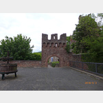
The original Hohenstaufen castle has been destroyed down to the archway and the massive foundations of the keep.
Today there is a restaurant with a dominant window front facing the valley and a vi. . . FURTHER . . .
| SightseeingEsskastanien-Lehrpfad
deutschland 63911 Klingenberg am Main
The Klingenberger sweet chestnut nature trail offers all those interested the opportunity to find out about the cultural and historical background of the sweet chestnut on 13 information boards, as we. . . FURTHER . . .
The Klingenberger sweet chestnut nature trail offers all those interested the opportunity to find out about the cultural and historical background of the sweet chestnut on 13 information boards, as we. . . FURTHER . . .
 |
| Deutschland - Der Limes, Main-Donau
Die römische Grenzlinie verläuft von der Nordsee entlang von Rhein, Main und Donau bis ans Schwarze Meer.
1 Niederlande-Deutschland, von Leiden bis Heilbronn, ID2597010
2 Deutschland, Main-Donau. . . FURTHER . . .
1 Niederlande-Deutschland, von Leiden bis Heilbronn, ID2597010
2 Deutschland, Main-Donau. . . FURTHER . . .
 | Hiking
Wanderung von Klingenberg nach Erlenbach
Deutschland 63911 Klingenberg am Main
Hike from Klingenberg to Erlenbach through the vineyards and back. At the beginning it goes to the village of Klingenberg and then into the vineyards. On the way back it gets a bit exciting and you sh. . . FURTHER . . .
Hike from Klingenberg to Erlenbach through the vineyards and back. At the beginning it goes to the village of Klingenberg and then into the vineyards. On the way back it gets a bit exciting and you sh. . . FURTHER . . .
Selected service points
 | AmazonHub
Amazon Hub Locker - julia
deutschland 63820 Elsenfeld Erlenbacher Straße 37
shell
shell
| AmazonHubAmazon Hub Locker - mando
deutschland 63906 Erlenbach am Main Elsenfelder Straße 37
shell
shell
Selected gastronomy
 | Guest House
Wanderheim Klingenberg
 deutschland 63911 Klingenberg am Main Kastanienweg
Hiking home with overnight accommodations open on weekends, public holidays and every 2nd Wednesday, home-style cooking, beautiful location in the forest above Klingenberg directly at the lookout tower
| Guest HouseWeingut Lutz - Häckerstube
deutschland 63911 Klingenberg am Main Ludwigstraße
large, cozy Häckerstube with lots of space and tasty, rustic cuisine
large, cozy Häckerstube with lots of space and tasty, rustic cuisine
 | eMail
Restaurant Bernd und Ursel Gogl
deutschland 63839 Kleinwallstadt An der Lederfabrik
| eMaildeutschland 63911 Klingenberg a. Main, Trennfurt Rathausstrase
| eMaildeutschland 63911 Klingenberg a. Main, Trennfurt Höhbergstrase
 | Cafe
Clingenburg
deutschland 63911 Klingenberg am Main Sonnenweg
motorhome places Obernburg-am-main in these books
General Pois
 | church
St. Peter und Paul
Deutschland 63906 Erlenbach Hauptstraße 64
There was a church here as early as the 12th century.
The current neo-Gothic building was erected around 1907. Major renovations took place in 1964.
The Albiez organ deserves a special mention.
There was a church here as early as the 12th century.
The current neo-Gothic building was erected around 1907. Major renovations took place in 1964.
The Albiez organ deserves a special mention.
| churchSt. Josef in Mechenhard
Deutschland 63906 Erlenbach Mechenharder Straße 152
The church was built in 1752. In 1962 a major renovation took place.
Noteworthy are:
The altar mural by Lukas Gastl
A 16-lamp chandelier
The church was built in 1752. In 1962 a major renovation took place.
Noteworthy are:
The altar mural by Lukas Gastl
A 16-lamp chandelier
| churchSt. Karl Borromäus
Deutschland 63906 Erlenbach Kirchplatz 2
The church is dedicated to Saint Charles, Archbishop of Milan and ´Angel of the Plague Victims´.
1969 major modifications took place.
The church is dedicated to Saint Charles, Archbishop of Milan and ´Angel of the Plague Victims´.
1969 major modifications took place.
 | General practitioners
Allgemein
deutschland 63911 Klingenberg a. Main, Trennfurt Rathausstrase
dr Reinfried Galmbacher, general medicine.
Von-Mairhofen-Str. 9, Klingenberg.
phone 09372-30 65 or 27 27
dr Reinfried Galmbacher, general medicine.
Von-Mairhofen-Str. 9, Klingenberg.
phone 09372-30 65 or 27 27
 | Bakery
Baecker
deutschland 63911 Klingenberg a. Main, Trennfurt Rathausstrase
Bakery and confectionery Der Brotmacher, branch Rathausstr. 15, Klingenberg am Main.
phone 09372-20 17 3
Bakery and confectionery Der Brotmacher, branch Rathausstr. 15, Klingenberg am Main.
phone 09372-20 17 3