Warbsen Germany
Europe´s bigest motorhome-portal
from motorhome drivers for motorhome driver
start
Warbsen, Information and images


Video films of the place and surroundings
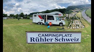

Motorhome place Am Forstbach

 37640 Warbsen Germany
Pay for use site 5 Euro


")


 Selected parking spaces
 | general parking lot
deutschland Holenberg
 |
| Parkenwander
deutschland 37619 Pegestorf B 83
Selected sights
 | Hiking
Wilder Vogler
deutschland 37642 Holenberg
From the sports field in Holenberg you can hike directly into the forest. For a distance of about 1800 meters, there are slight ups and downs, mainly on the wide gravel paths of the lower slopes of the Vogler. After a bridge, turn left into Hüttebachtal. You hike along natural meadows until you come across a path that leads slightly uphill from the left side of the valley to the right side of the forest. From here a 2 km long Ebersnacken trail leads uphill, first on a gravel path and then on a forest path. Shortly before the summit you meet the Weserberglandweg, with which your hike now runs parallel. After approx. 200 m you will reach Vogler´s highest elevation, Ebersnacken, at 460 m. The 26 m high Ebersnacken tower offers a magnificent panorama. The hike now continues downhill.
You walk about 600 m along the Voglerkammweg until you turn right and walk down the forest path to the Holenberg. Just before you reach the place, you will see Holzberg in the distance. Turn right at Holenberg. On the grass path, past the Rasplatz, you reach the starting point at the Holenberg sports field.
 | lock
Schloss Bevern
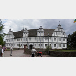 37639 Bevern Am Schloss
The representative building in the style of the Weser Renaissance was completed in 1612. The builder of the four-wing complex with a square inner courtyard was Statius von Münchhausen.
The district of Holzminden took over the castle in 1986 and expanded it into a cultural center.
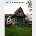
| HikingZweitürmetour
deutschland 37619 Bodenwerder
Sights: Enjoy a breathtaking view of the Weser Valley from the Bismarck Tower and the Royal Palace.
Sights: Enjoy a breathtaking view of the Weser Valley from the Bismarck Tower and the Royal Palace.
 | observation tower
Bodoturm
Deutschland 37619 Bodenwerder Kammweg
On the 412 m high Zimmertalskopf stands the 20 m high tower, built in steel skeleton construction.
On the 412 m high Zimmertalskopf stands the 20 m high tower, built in steel skeleton construction.
 | tower
Ebersnackenturm
deutschland 37619 Kirchbrak Kammweg
Ebersnackenturm 26m, 460m above sea level with a view of the Teuteburg Forest and Harz
Ebersnackenturm 26m, 460m above sea level with a view of the Teuteburg Forest and Harz
motorhome places Warbsen in these books
General Pois
 |
| 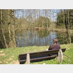 deutschland 37632 Eschershausen, Scharfoldendorf Ws¤scheweg
Stauweiher mit Kinderspielplatz und Grillplatz mit Schutzhütte
 | Shell
Shell
deutschland 37619 Bodenwerder Rühler Straße
Shell petrol station in Bodenwerder
Shell petrol station in Bodenwerder
 | ätere Stadtgalerie
Bodenwerder
 | Castle
Weserrenaissance Schloß Bevern
deutschland 37639 Forst Schloss
 | Tourist Info
TouristInfo
 Deutschland 37639 Bevern Am Schloss
 | church
St. Johannes
Deutschland 37639 Bevern Am Schloss
| churchSt. Hedwig
Deutschland 37639 Bevern Königsberger Straße
 | monastery
Kloster Amelungsborn
 | Rewe
Rewe
deutschland 37639 Bevern
| ReweRewe Bodenwerder
Deutschland 37619 Bodenwerder Rühler Straße 32
 |
| Nahkauf
deutschland 37639 Lobach
 | Autogas
AUTOFIT-SERVICE-PARTNER W.SPARKUHLE
deutschland 37643 Negenborn, Ilse-Siedlung Neue Strase
 | only for shopping
Einkaufsparkplatz
deutschland 37639 Bevern